
|
|
#301
 10-16-2010, 01:23 PM
|
||||
|
||||
|
Quote:
Now if people think the colours in Olegs shots are closer to the colours of southern England than the ones i posted, thats fine with me... maybe they can find one real picture that matches that mix of colours and looks like Olegs screen shot, and then post it here. 
|
|
#302
10-16-2010, 01:24 PM
|
|||
|
|||
|
Quote:
They are not exact textures. But using as a reference professional photos, accessble info for locations of vegetables, rural zones, etc Yes it is isn't exactly satellite map... but we should model 1940... Direct satellite maps would be good for modern sims... however they should too much reworked in term to clean from all the objects, like cars on the roads, etc. Also they should be reworked in colors, contrast, etc because from the space they are looking not like on the ground or even not like from 10 km altitude. So.. we really doing better than some offers.
|
|
#303
10-16-2010, 01:25 PM
|
|||
|
|||
|
S!
Used the mail
|
|
#304
10-16-2010, 01:28 PM
|
|||
|
|||
|
Quote:
The "3D" arrow cone in CFS3 was nice in the sense that it gave you a good hint on the relative angle enemy vs you, but it was always only activated for one enemy at a time (the selected enemy) and was ALWAYS in the dead middle of your screen -- an incredible stupid decision if you ask me. Ideally I would like a combination of both...Olegs arrows and super quick identification with distance hints work just great, add to that maybe a 3D version of one of those arrows for the selected enemy giving you relative angle. I don't know, just thinking loud here.
|
|
#305
10-16-2010, 01:28 PM
|
||||
|
||||
|
Quote:
 8G ram I assume and 64 OS? Any help
|
|
#306
10-16-2010, 01:30 PM
|
|||
|
|||
|
S!
I think the arrows work fine as we are "conditioned" in IL-2 to them. And easy to see blue or red as same is also in IL-2. Maybe you could have an option to just leave enemy arrows and discard own side etc.
|
|
#307
10-16-2010, 01:32 PM
|
|||
|
|||
|
Quote:
There's an awfull lot of variation in the vegetation here and this is only a few square miles. 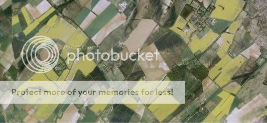 Coulours are always gonna be open to artistic interpretation.
|
|
#308
10-16-2010, 01:34 PM
|
||||
|
||||
|
Quote:
The shapes and textures of the fields looks spot on.
|
|
#309
10-16-2010, 01:36 PM
|
|||
|
|||
|
Quote:
I will explain by a bit other way in shotest way. 1. The purpose of the shots was to show sharpnes of the ground image from altitude and on great distances. 2. Your posted photos are not like the human eye see it in real time 3. I answered you that the colors are not final. For all: Because we are fighting with HDR technology that damages some time real colors we tune the texture colors already long time. And now this work is close to final, but need to be tuned exact tint and saturation of textures color - one for all HDR in its way how it is used by all (compression) - great mistake of someone... We will use it minimal... close to zero. Because it is impossible already to remove. Just in cockpit it gives some advantage. But overal - it is global mistake of all developers. Probably main world developers understood it already too and tuned it to minimal. I think many photographers will confirm my thought if the speech is about realistic lifelike photos and not about toxic colors that someone think is cool... (some time really cool if it is the art using this toxic colors especially
|
|
#310
10-16-2010, 01:36 PM
|
|||
|
|||
|
S!
But you can adjust some of the colors in your GFX card control panel if needed to get a color suiting you, regarding the pics and terrain color discussion.. I use that if I want more color or less of it. I think the screenies really depend on how the system is adjusted etc. And with Final we will finally see it Last edited by Flanker35M; 10-16-2010 at 01:39 PM. Reason: Adjust text
|
 |
|
|


 Linear Mode

