
|
|
|||||||
| FM/DM threads Everything about FM/DM in CoD |
|
|
Thread Tools | Display Modes |
|
#11
 09-21-2012, 01:58 AM
|
|||
|
|||
|
Edit from first post found an Ooops in the calcs ... corrected made error even less. I deleted the original post and re post here.
Here is my contribution in trying to sort this perceived issue out. Happy for anyone to pull apart and destroy my method,calculations and or assumptions. SPEED TEST METHOD Picked 2 easily seen landmarks far enough apart to provide reasonable distance. 2 landmarks chosen Dungeness point lighthouse and Capr Griz Nez. Then measured actual real world distance in Google maps 42.59Km  Next in CLOD FMB established map Grid size via X coordinates between two adjoining vertical grid lines. This was 10,000 metres. In FMB set up BF109 at 10m over Dungenes point at 0700 hrs at 420Kmh. Set Destination Waypoint Griz Nez at 420Kmh. FMB Computed Time interval 6min. at 6min 420Kmh gives 42Km ... Close enough to real world distance. Conclusion CLOD map is 1:1, OK to use for time Distance Speed checks. 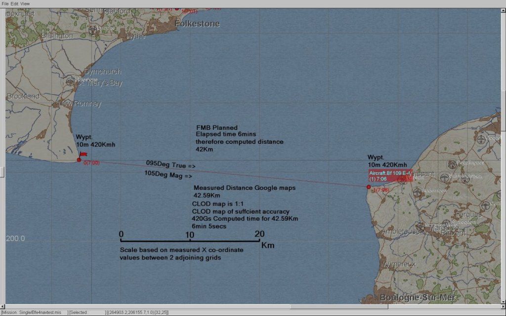 Set up Ships along the planned track to allow for easy navigation. Next Flew the course 4 times 2 East bound and 2 Westbound to ensure the cancellation of any hidden/latent winds on the map. (just as well) Each run commenced inland of the initial waypoint at Sea level Stabilised on speed 420Kmh IAS Wings level in Trim. Stop watch started over First waypoint and stopped over end waypoint IAS maintained +-5Kmh throughout using Wonder woman mode Large ASI. RESULTS: SE Bound Run1 Elapsed time 5:25 SE Bound Run 2 Elapsed time 5:23 NW Bound Run 1 Elapsed time 6:25 NW Bound Run 2 Elapsed time 6:18 (Average West bound runs take 57secs longer) Total Time 23min 51 secs Given the consistent significant diff between SE and NW runs I can only conclude that there is some hidden wind (or retroverted Coriolis) on the base map. Runs in both directions will negate Wind affect if results are averaged. Using Real World distances. 42.59Km X 4 = 170.36Km 170.36Km at 420Kmh would take 24min 20secs I achieved in CLOD test 23min 51 secs. So over say 23mins 51secs the diff was 29 seconds Over 1 hr the difference would be 73 seconds 73 seconds at 420Kmh equates to 8.51Km Experimental speed error 8.51Kmh i.e. about 2.0% Considering all the various potential errors in the methodology: Google map distance measurement CLOD FMB map accuracy Exact Stopwatch activation location Slight IAS piloting errors Assuming IAS=TAS at Sea level (which we know is close but not exact) a 2.0% or in real numbers 8.5 kmh variance is insignificant . Conclusion Displayed BF109E4 IAS is accurate. NOTES Be careful using timed runs over geographic features as some hidden wind is IMO resident on the base map. Flying the track both ways and averaging the results should cancel out the wind effect. If you want to test the RAF types then the target IAS based on Statue mile would be 261MPH. Test Mission file attached Last edited by IvanK; 09-21-2012 at 08:42 AM. 
|
| Thread Tools | |
| Display Modes | |
|
|


 Threaded Mode