Fulqrum Publishing Home   |   Register   |   Today Posts   |   Members   |   UserCP   |   Calendar   |   Search   |   FAQ

Go Back   Official Fulqrum Publishing forum > Fulqrum Publishing > IL-2 Sturmovik: Cliffs of Dover

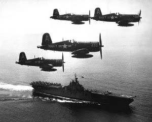
IL-2 Sturmovik: Cliffs of Dover Latest instalment in the acclaimed IL-2 Sturmovik series from award-winning developer Maddox Games.

Reply
 
Thread Tools Display Modes
  #1  
Old 04-11-2012, 11:15 PM
von Pilsner von Pilsner is offline
Approved Member
 
Join Date: Apr 2011
Posts: 377
Talking WWII Maps are Here!

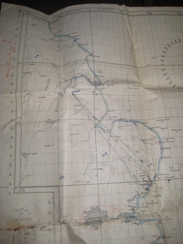
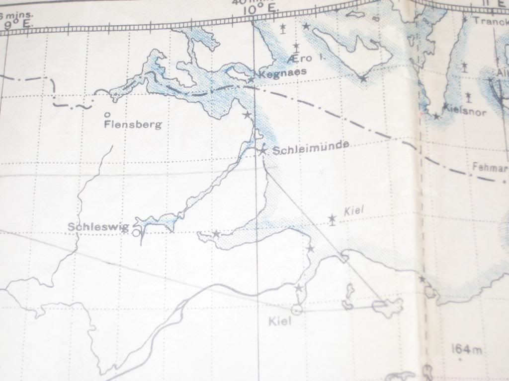
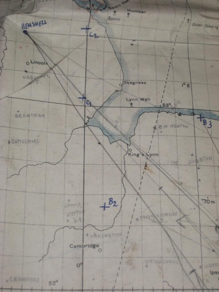
Rather than hide them on page 3 of the looking for maps thread, I started a new map thread...

GSGS4369 - 8 (Strait of Dover)


I found some good maps at this site (including original version of above map): http://www.8thafhsoregon.com/archive...Lawrence-Fick/

GSGS 4072
Berlin
Strasbourg
Frankfurt

And a few more here: http://commons.wikimedia.org/wiki/Wo..._maps_(Europe)

And the Lorraine Campaign Map

Last edited by von Pilsner; 04-11-2012 at 11:22 PM.
Reply With Quote
  #2  
Old 04-11-2012, 11:57 PM
badaboom's Avatar
badaboom badaboom is offline
Approved Member
 
Join Date: Oct 2007
Posts: 76
Default

Great find!!! THX!!
__________________

Patrick
Reply With Quote
  #3  
Old 04-12-2012, 08:33 AM
PeterPanPan PeterPanPan is offline
Approved Member
 
Join Date: Oct 2009
Location: London, UK
Posts: 559
Default

Great, thanks, printing now!
PPP
__________________
Intel Core i7 2600 3.4 GHz | 1GB Gainward GTX 460 GS | Corsair 4GB XMS3 PC3-12800 1600MHz (1x4GB) | Gigabyte GA-P67A-UD3P B3 (Intel P67) | Windows 7 Home Premium 64 BIT | 600W PSU | 1 TB SATA-II HDD 7200 32MB | 22" Samsung T220 screen.
Reply With Quote
  #4  
Old 04-12-2012, 10:40 AM
JG5_emil's Avatar
JG5_emil JG5_emil is offline
Approved Member
 
Join Date: Jul 2010
Posts: 331
Default

I have a map which covers England, France and Germany but it is a 1939 one. I believe it is original and was used by bomber navigators. There are routes marked on it including flak batteries and DR what ever that means.
Reply With Quote
  #5  
Old 04-12-2012, 10:43 AM
JG5_emil's Avatar
JG5_emil JG5_emil is offline
Approved Member
 
Join Date: Jul 2010
Posts: 331
Default

[IMG][/IMG]
Reply With Quote
  #6  
Old 04-12-2012, 10:44 AM
JG5_emil's Avatar
JG5_emil JG5_emil is offline
Approved Member
 
Join Date: Jul 2010
Posts: 331
Default

Quote:
Originally Posted by JG5_emil View Post
[IMG][/IMG]


Reply With Quote
  #7  
Old 04-12-2012, 12:14 PM
JVM JVM is offline
Approved Member
 
Join Date: Oct 2007
Posts: 188
Default

Quote:
Originally Posted by JG5_emil View Post
I have a map which covers England, France and Germany but it is a 1939 one. I believe it is original and was used by bomber navigators. There are routes marked on it including flak batteries and DR what ever that means.
Hello!

In this context "DR" means probably "Dead Reckoning", which means branch which have to be flown only with the guidance of the compass and the (gyroscopic) heading indicator, without relying on ground clues or navaids (which were non existent on the way to the target!).
This was on this kind of flying you really appreciated a competent navigator...Dead Reckoning skills have a tendency to become scarce in the western part of the world, due to abundance of navaids but in large land masses like Australia, Africa or South America, and the north and south poles, this is the only way to get home if your GPS is letting you down...

JV
Reply With Quote
  #8  
Old 04-12-2012, 12:18 PM
JG5_emil's Avatar
JG5_emil JG5_emil is offline
Approved Member
 
Join Date: Jul 2010
Posts: 331
Default

Quote:
Originally Posted by JVM View Post
Hello!

In this context "DR" means probably "Dead Reckoning", which means branch which have to be flown only with the guidance of the compass and the (gyroscopic) heading indicator, without relying on ground clues or navaids (which were non existent on the way to the target!).
This was on this kind of flying you really appreciated a competent navigator...Dead Reckoning skills have a tendency to become scarce in the western part of the world, due to abundance of navaids but in large land masses like Australia, Africa or South America, and the north and south poles, this is the only way to get home if your GPS is letting you down...

JV

Thanks for the info. I have tried my best to research the map. Many of the flights are from Hemswell so this map is either from a time when Hampdens were being flown out of there by RAF or maybe Wellingtons possibly by a Polish squadron.

One day I will travel down to the museum and ask them.
Reply With Quote
  #9  
Old 04-13-2012, 07:05 AM
Friendly_flyer's Avatar
Friendly_flyer Friendly_flyer is offline
Approved Member
 
Join Date: Oct 2007
Location: Oslo, Norway
Posts: 412
Default

Nice find!
__________________
Fly friendly!


Visit No 79 Squadron vRAF

Petter Bøckman
Norway
Reply With Quote
  #10  
Old 04-16-2012, 09:16 PM
von Pilsner von Pilsner is offline
Approved Member
 
Join Date: Apr 2011
Posts: 377
Default

If anyone plays RoF, I found a nice map of the Western Front (1917) as well...


The map is huuuuge (11608x8696) so I zipped it up for easier downloading....
Reply With Quote
Reply


Posting Rules
You may not post new threads
You may not post replies
You may not post attachments
You may not edit your posts

BB code is On
Smilies are On
[IMG] code is On
HTML code is Off

Forum Jump


All times are GMT. The time now is 05:56 PM.


Powered by vBulletin® Version 3.8.4
Copyright ©2000 - 2024, Jelsoft Enterprises Ltd.
Copyright © 2007 Fulqrum Publishing. All rights reserved.