Fulqrum Publishing Home   |   Register   |   Today Posts   |   Members   |   UserCP   |   Calendar   |   Search   |   FAQ

Go Back   Official Fulqrum Publishing forum > Fulqrum Publishing > IL-2 Sturmovik: Cliffs of Dover > Gameplay questions threads

Gameplay questions threads Everything about playing CoD (missions, tactics, how to... and etc.)

Reply
 
Thread Tools Display Modes
  #11  
Old 01-01-2012, 07:05 AM
Manu22 Manu22 is offline
Approved Member
 
Join Date: May 2011
Location: Québec, Canada
Posts: 18
Default

you dont need to correct the deviation with the protractor because it is drawn on the map. You use our angle of deviation something like West 10, on your own compass to compense the angle of the pole , that change evey year.
Reply With Quote
  #12  
Old 01-01-2012, 10:30 AM
jimbop jimbop is offline
Approved Member
 
Join Date: Jan 2011
Location: Australia
Posts: 1,064
Default

Quote:
Originally Posted by jf1981 View Post
Determine your speed base factor : 60/Speed
e.g.
BF109@300km/h bf=0,20
SPIT@240mph bf=0,25

ETA (min) = distance x bf
e.g.
10 km at 300 kmh => ETA 2 min
10 miles at 240 mph => ETA 2,5 min (2 min 30")

Use any tool to calculate true route on map e.g. 315°, add 10° for magnetic route, follow 325 mag compass.

Since you can roughly pick up the distance with finger or anything from the map scale and report it on the map, you can have anytime with the help of your fingers that distance to waypoint or target.

As well you can use a tool (I have one) or the map ruler/compass (right click on map -> tools) - this is longer however - to measure the route to newt point, or you can estimate which works fine when accuracy is not a big deal or if route is short (eg. less 20 km / 15 miles).

Navigation is easy, pick a route, convert to magnetic by adding 10°, a distance, convert to time by multiplying by your base factor and start a stopwatch, follow your magnetic compass.

With some experience, the only issue you will encounter is wind, the method is perfect.
Nicely explained, thanks.
Reply With Quote
  #13  
Old 01-01-2012, 02:48 PM
droz droz is offline
Approved Member
 
Join Date: Sep 2009
Posts: 127
Default

I wonder if there is a way to mod in a protractor for use on the map as a tool? hrm.
Reply With Quote
  #14  
Old 01-01-2012, 03:29 PM
Foo'bar Foo'bar is offline
Approved Member
 
Join Date: Oct 2007
Location: Niedersachsen, Deutschland
Posts: 662
Default

Quote:
Originally Posted by droz View Post
I wonder if there is a way to mod in a protractor for use on the map as a tool? hrm.
Rightclick the CloD map and choose Tools -> Map Tools.
Reply With Quote
  #15  
Old 01-03-2012, 08:10 AM
MB_Avro_UK MB_Avro_UK is offline
Approved Member
 
Join Date: Dec 2007
Location: London, England (Not European!).
Posts: 755
Default

Wind direction and speed are the two vital factors. But difficult to calculate.

It can be done with a Dalton flight computer. You have to compare a navigation Fix with your estimated position on the map. (A Fix can be obtained for instance from at least two radio Beacons).

It's a very complex subject and that's why navigators training was so lengthy.

Flying long distances at night or in cloud exposed in WW2 the great weaknesses in Dead Reckoning (DR) navigation.

The RAF bombers early in WW2 relied on Dead Reckoning at night. Most of the bombs dropped were miles off target.

Look up the one in 60 rule.

Flying in daylight within sight of the ground though is far simpler.

Best Regards,
MB_Avro
Reply With Quote
  #16  
Old 01-03-2012, 09:24 AM
SlipBall's Avatar
SlipBall SlipBall is offline
Approved Member
 
Join Date: Oct 2007
Location: down Island, NY
Posts: 2,719
Default

Quote:
Originally Posted by MB_Avro_UK View Post
Wind direction and speed are the two vital factors. But difficult to calculate.

It can be done with a Dalton flight computer.

Best Regards,
MB_Avro


Along with all the book's and reading material we were required to purchase the Dalton E6-B for navigation training...Side note, Dalton I believe was born and raised in England,...edit: oops, born and raised in the States.

For those interested..http://www.asa2fly.com/files/support/E6B_Manual.pdf
__________________


GigaByteBoard...64bit...FX 4300 3.8, G. Skill sniper 1866 32GB, EVGA GTX 660 ti 3gb, Raptor 64mb cache, Planar 120Hz 2ms, CH controls, Tir5

Last edited by SlipBall; 01-03-2012 at 10:31 AM.
Reply With Quote
  #17  
Old 01-03-2012, 10:03 AM
Skoshi Tiger Skoshi Tiger is offline
Approved Member
 
Join Date: Nov 2007
Location: Western Australia
Posts: 2,197
Default

Quote:
Originally Posted by SlipBall View Post
Along with all the book's and reading material we were required to purchase the Dalton E6-B for navigation training...Side note, Dalton I believe was born and raised in England.

For those interested..http://www.asa2fly.com/files/support/E6B_Manual.pdf
I have the Kane version from my PPL training!

manual here http://sliderule.ozmanor.com/man/man-download.html


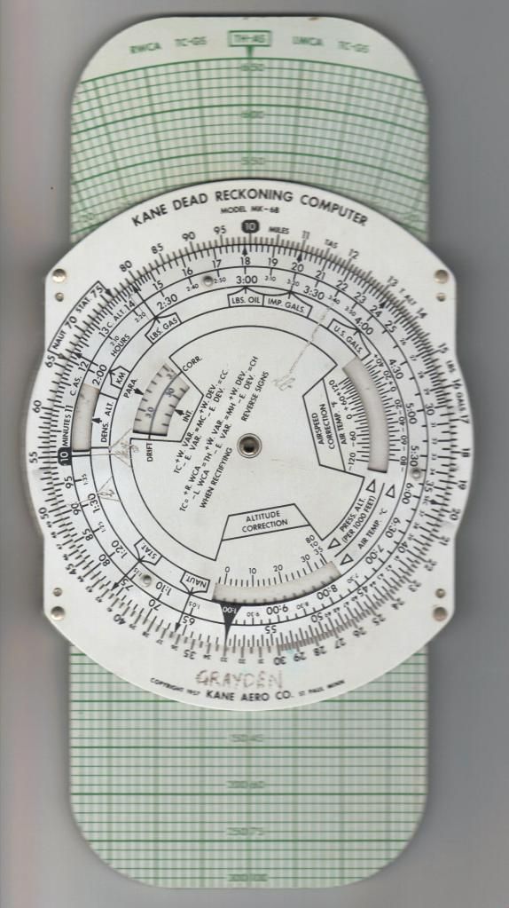
We also need temerature to calculate TAS. Unfortunately I couldn't find one in the Blenheim!

Last edited by Skoshi Tiger; 01-03-2012 at 10:07 AM.
Reply With Quote
Reply


Posting Rules
You may not post new threads
You may not post replies
You may not post attachments
You may not edit your posts

BB code is On
Smilies are On
[IMG] code is On
HTML code is Off

Forum Jump


All times are GMT. The time now is 03:13 PM.


Powered by vBulletin® Version 3.8.4
Copyright ©2000 - 2024, Jelsoft Enterprises Ltd.
Copyright © 2007 Fulqrum Publishing. All rights reserved.