
|
|
|||||||
| IL-2 Sturmovik: Birds of Prey Famous title comes to consoles. |
 |
|
|
Thread Tools | Display Modes |
|
|
|
#1
 07-05-2011, 01:14 AM
|
|||
|
|||
|
Quote:
A squadron of Hurricanes attempted this tonight on the 360...... and failed miserably.We had to stop almost immediately to ask for direction. Our first issue was the home airfield.... where is it? The only one we could find was slightly south of Berlin. We then got confused with "Britz, and Heinersdorf", Britz being below Berlin and Heinersdorf being above it, (we had to resort to google earth). We ultimately found the target, but only because of the use of google earth. The instructions seem detailed enough, so its clearly a mistake on our part. We just struggled with the headings and airfield. Does anyone have the locations marked on a Berlin map? We will try this again tomorrow night. Cheers fella's. 
|
|
#2
07-05-2011, 01:20 AM
|
||||
|
||||
|
Was that another race to post Foz?
__________________
 XBL GT: - Robotic Pope HyperLobby CS: - Robot_Pope
|
|
#3
07-05-2011, 01:24 AM
|
|||
|
|||
|
Quote:
I'll give you this one. Thats 1-1. We should retry the flight path tomorrow, get our bearings back.
|
|
#4
07-05-2011, 11:25 PM
|
||||
|
||||
") I wrote the coordinates wrong, will fix, srry!
__________________
Jagdwaffe 
|
|
#5
07-06-2011, 12:28 AM
|
||||
|
||||
|
Quote:
__________________
XBL GT: - Robotic Pope HyperLobby CS: - Robot_Pope
|
|
#6
07-06-2011, 01:52 PM
|
|||
|
|||
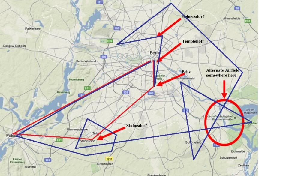 Here's a map i was given, I've added to it a little. RED shows where i believe we were meant to go? I think thats right. BLUE shows where we actually went haha. Uopn reaching North of Berlin instead of South, thats when we gathered we were lost so cheated somewhat and summoned google earth to assist us
|
|
#7
07-06-2011, 06:20 PM
|
|||
|
|||
|
For the culturally interested:
Potdam has no castle, it has a load of palaces, parks and gardens, though. Cecilienhof is where the Potsdam conference took place, it was a residence for the last German Kaiser. The palace in the picture is not Cecilienhof, it is the Belvedere on the Pfingstberg, a smaller royal recreational residence on a hill, very close to Cecilienhof. Belvedere from the French good view, because you get an awesome view over the Havel river, islands and hills as well as the palaces and gardens of Postdam and south-west Berlin. Neither palace was disabled by bombs, don't think they actually were targeted. Cecilienhof, only a couple of dozen meters away from the Berlin wall, was kept in good condition all the time, with lots of tourists coming for a visit, but the Belvedere was closed to the public and left to rot up to 1989, because it did not only give a good view of the landscape, but also of a Soviet military component harbouring thousands of Soviet soldiers, ready to attack the West / defend the East in case the Cold War got hot. It was reconstructed after 1989 and is open to the public now. Last edited by JtD; 07-06-2011 at 06:22 PM.
|
|
#8
07-06-2011, 08:05 PM
|
||||
|
||||
|
Quote:
[wikipedia] During World War II, the area served as a military training area, mostly for Flak troops. It was destroyed in Allied air raids. I'm going to check it out next time i'm over berlin.
__________________
XBL GT: - Robotic Pope HyperLobby CS: - Robot_Pope Last edited by Robotic Pope; 07-06-2011 at 08:12 PM.
|
|
|
|


 Hybrid Mode
