Fulqrum Publishing Home   |   Register   |   Today Posts   |   Members   |   UserCP   |   Calendar   |   Search   |   FAQ

Go Back   Official Fulqrum Publishing forum > Fulqrum Publishing > IL-2 Sturmovik

IL-2 Sturmovik The famous combat flight simulator.

Reply
 
Thread Tools Display Modes
  #1  
Old 10-21-2010, 11:36 AM
Hoverbug Hoverbug is offline
Approved Member
 
Join Date: Nov 2009
Posts: 29
Default

If it's an escape and evasion map, it'll be usually be silk. If it's an aeronautical chart, it'll be on paper. You really do have some latitude on how it's printed - especially if you're not actually reproducing a period map.
Reply With Quote
  #2  
Old 10-21-2010, 11:54 AM
RedToo's Avatar
RedToo RedToo is offline
Approved Member
 
Join Date: Oct 2007
Location: UK
Posts: 261
Default

I have a 1930's RAF map of the south east of England. It is paper on open weave linen. I am at work at the moment. I will post more details when I get home.

RedToo.
__________________


43 Squadron.

My 'Waiting for Clodo' thread: http://tinyurl.com/bqxc9ee
Reply With Quote
  #3  
Old 10-21-2010, 11:59 AM
DD_crash's Avatar
DD_crash DD_crash is offline
Approved Member
 
Join Date: Oct 2007
Location: Buckley North Wales
Posts: 307
Default

Quote:
Originally Posted by RedToo View Post
I have a 1930's RAF map of the south east of England. It is paper on open weave linen. I am at work at the moment. I will post more details when I get home.

RedToo.
Old time (1950s) Ordenance Survey maps used to be paper backed with linen. I dont think that things would have changed much in 10 years.
Reply With Quote
  #4  
Old 10-21-2010, 12:00 PM
Spudkopf's Avatar
Spudkopf Spudkopf is offline
Approved Member
 
Join Date: Nov 2007
Location: Australia
Posts: 248
Default

Didn't the Germans just use the Michelin Guide?
__________________
Spud

Reply With Quote
  #5  
Old 10-21-2010, 01:06 PM
W32Blaster W32Blaster is offline
Approved Member
 
Join Date: Feb 2010
Posts: 83
Default

... always used secret weapon:

google maps

Reply With Quote
  #6  
Old 10-21-2010, 08:53 PM
WTE_Galway WTE_Galway is offline
Approved Member
 
Join Date: Jul 2008
Posts: 1,207
Default

Quote:
Originally Posted by luthier View Post
Thanks everyone for your help, but I still need more help with this. We didn't have questions about the map contents per se. We're actually pretty good on the content. We already have a high-res map of our area, which is what would be printed. We just don't know what to print it on, and how to print it.

And I'm still not sure whether this would need to be on cloth, silk, or paper. But since no one seemed to know much about these even on a forum full of aviation experts, I'm guessing the materials won't be a major deal, as long as the map itself is good.
Note that references to silk maps found so far refer exclusively to RAF "escape maps" which clearly were pointless during the Battle of Britain. From my experience printing directly on linen or silk was rare. Much more common was a paper map backed with something like linen.

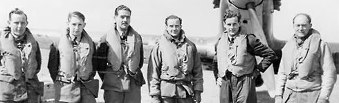
I have found a few photos of crew in a he111 using maps in flight. One shows the co-pilot using what looks very much like folded paper. The second looks more interesting the as map appears to be mounted on a stiff folding board with two panels each about 40cm wide by 30 cm high. I will post these up when I get a chance to scan them.

Also remember that regularly updated/changed maps like strip maps and individual airfield maps would almost certainly be just paper. In addition the pilot/navigator generally drew on these maps with a "chinagraph" pencil meaning they had a limited operational life before becoming cluttered and needing replacement.

On the other hand, the 1940 equivalent of sectionals and WAC charts were likely to be backed with linen or some other material for longevity.
Reply With Quote
  #7  
Old 10-21-2010, 09:32 PM
Abbeville-Boy Abbeville-Boy is offline
Approved Member
 
Join Date: Oct 2007
Posts: 196
Default

is map for our knee? good booklet would be too
Reply With Quote
  #8  
Old 10-21-2010, 11:19 PM
swiss swiss is offline
Approved Member
 
Join Date: Mar 2010
Location: Zürich, Swiss Confederation
Posts: 2,266
Default

Quote:
Originally Posted by Abbeville-Boy View Post
is map for our knee? good booklet would be too
the map is mainly deco - I hope we'll have an ingame map too.
-> silkmap= cool
Reply With Quote
  #9  
Old 10-22-2010, 12:33 AM
Skoshi Tiger Skoshi Tiger is offline
Approved Member
 
Join Date: Nov 2007
Location: Western Australia
Posts: 2,197
Default

Although a printed map in the box would be very cool, Please put a PDF of the map in the distribution! (like the New Guinea map on the PF disk - or better)

This thread has made me remember. Some where around the traps is the book on map reading and cartography my grandfather was issued when he joined the militia (Dad's army type - he was a WWI veteran) at the begining of WWII.

Will have to search it out!

Cheers!
Reply With Quote
  #10  
Old 10-25-2010, 10:13 PM
jocko417 jocko417 is offline
Approved Member
 
Join Date: Oct 2009
Posts: 43
Default

...and said under Elvis' breath while leaving said building...


Quote:
Originally Posted by luthier View Post
Thanks everyone for your help, but I still need more help with this. <snip> We just don't know what to print it on, and how to print it.
Reply With Quote
Reply


Posting Rules
You may not post new threads
You may not post replies
You may not post attachments
You may not edit your posts

BB code is On
Smilies are On
[IMG] code is On
HTML code is Off

Forum Jump


All times are GMT. The time now is 02:14 AM.


Powered by vBulletin® Version 3.8.4
Copyright ©2000 - 2025, Jelsoft Enterprises Ltd.
Copyright © 2007 Fulqrum Publishing. All rights reserved.