
|
|
|||||||
| FM/DM threads Everything about FM/DM in CoD |
 |
|
|
Thread Tools | Display Modes |
|
|
|
#1
 09-22-2012, 12:31 PM
|
||||
|
||||
|
Quote:
OK today I did the almost exact test as you did (my way to travel was 41.8Km from point to point). Here are my results (no wind, 500m): From France to GB, 300km/h, 41.8km: -> estimated time: 8min 21sec G.50 = 7min 37sec = 44sec difference He 111H = 7min 18sec = 1min 3sec difference From GB to France, 300km/h, 41.8km: G.50 = 7min 00sec = 1min 21sec difference He 111H = 6min 48sec = 1min 33sec difference So both planes fly faster from GB to F (37sec the G.50 and 30sec the He111) Again, its not very bad but its a difference considering its done in an "laboratory environment" . However its not as bad as my first testing which was done almost exactely from E - W (260 degrees). To me it seems that - theres some kind of "secret wind" (considering the difference between GB-F, F-GB) or - the gauges dont work proper (considering the difference between He111 - G.50) And here my one way testing results from earlier: (no wind, HDG 260deg, 100m alt, 3min fliying time) Me110 C7: 248km/h (gauge) for 3min = 14km actual distance: 12,4. Difference = 1,6km Me1109E3: 250km/h (gauge) for 3min = 14,2km actual distance: 12,5. Difference = 1,7km SpitIa: 222km/h (138mph gauge) for 3min = 13,8km actual distance: 11,1. Difference = 2,7km Hurri (Rotol): 206km/h (128mph gauge) for 3min = 13,3km actual distance: 10,3. Difference = 3,0km He111H: 248km/h (gauge) for 3min = 14,4km actual distance: 12,4. Difference = 2,0km Last edited by NaBkin; 09-22-2012 at 12:37 PM. 
|
|
#2
09-22-2012, 12:51 PM
|
|||
|
|||
|
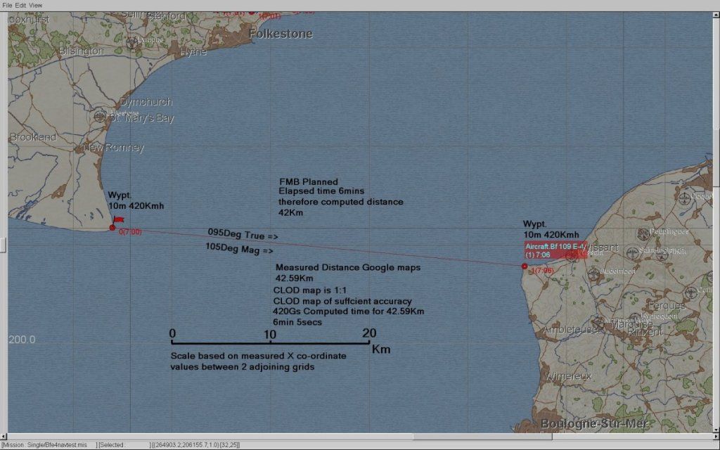
I suggest you do everything at sea level. 500m is to high it introduces a real difference between Indicated Airspeed (IAS) and True Air Speed (TAS). Doing the test at sea level pretty much eliminates this as IAS is very close to TAS.
I don't see any correction in your results for TAS. 500m Altitude on a Standard day would result in around 6Kmh diff between IAS and TAS. I will have a look at 3min test like yours but at sea level only. Personally I think 3 mins is too short a time period and magnifies any errors. You also need to always fly the test both ways to ensure cancellation of any wind effects. In addition I think you would be better off doing ALL your tests between to fixed markers a known distance apart rather than flying a time and seeing where you end up. There are issues transferring your perceived position to the map then measuring. Nothing to stop you precisely placing Ships at 10000m intervals using the Grid on the FMB map and using this as a test track. Timing between features a known distance apart is the way to go imo. Last edited by IvanK; 09-22-2012 at 10:46 PM.
|
|
| Thread Tools | |
| Display Modes | |
|
|


 Hybrid Mode
