
|
|
|||||||
| IL-2 Sturmovik The famous combat flight simulator. |
 |
|
|
Thread Tools | Display Modes |
|
|
|
#1
 10-21-2010, 02:29 PM |
|||
|
|||

There seems to be some sort of Communication Breakdown going on here. Let's take a closer look at Luthier's post and see if we can discern the secret meaning.
Quote:
Quote:
Quote:
What Material? As in what did they print the maps on? a. Paper b. Laminated paper c. Rayon d. The pilot's arm (tattoo) e. Silk f. Nylon g. Deli meats They are not asking you what to put on the maps, they are asking what to put the maps on! Things they don't need: Maps from AFTER the Battle of Britain. Non-Pilot maps. (maps not used by pilots) Pictures of the Map's Content. Incredibly off-topic Italian Babbling about post-war maps. If you don't know what the maps were printed on, then posting a picture of 1943 Poland is not going to help. Personally, I'm probably going to rule out silk/rayon/nylon or any other fabric since the pilots didn't need to hide their flight maps and required something foldable but semi-rigid so they could see it properly. Take a tissue, draw a picture on it, then try and read it with one hand. Odd are, the material they are looking for is some manner of paper/laminated paper, or card-stock. 
|
|
#3
10-21-2010, 02:41 PM
|
|||
|
|||
|
Quote:
|
|
#4
10-21-2010, 03:18 PM
|
||||
|
||||
|
TBH a pilot would nip down to the local shop, grab a map, pay the chap, Bob's your Uncle and Fanny's your Aunt.
The AM did release maps though to pilots; BoB versions are extremely scarce now-a-days. A simple map would have been made from paper (maybe linen-backed), and nice pre-war examples often come with a nice thick, brown paper cover; usually nicely AM marked too. There ya go  Don't muck around with that poncy silk and rayon malarky, they were produced from these materials but they had a specific reason; usually to do with escape/evasion if my memory serves me correctly. The tissue maps were made for escape, and were made to fold easily. These bore some resemblance to a handkerchief. However, this is post-BoB 
|
|
#5
10-21-2010, 04:18 PM
|
||||
|
||||
|
I remember old Ordnance Survey maps being paper backed with some sort of quite wide woven cloth, I don't know whether they were pre or post WW2. It should be possible to get hold of some I'd have thought, they seemed to be quite hard wearing. That was the point of the cloth, holding the shape when the paper fell apart at the fold lines (I think paper now has plastic in it or something, back then it was much less durable).
|
|
#6
10-21-2010, 05:11 PM
|
|||
|
|||
|
Quote:
I thought there were restrictions on the sale of maps in the UK during WW2?
|
|
#7
10-21-2010, 05:21 PM
|
||||
|
||||
|
Hi Luthier,
As promised some more info. on my RAF map. It was first published in 1938. Four pics - two of parts of the map, one of the whole map and one of the backing. Let me know if you want any more details, e.g, the rest of the key etc. 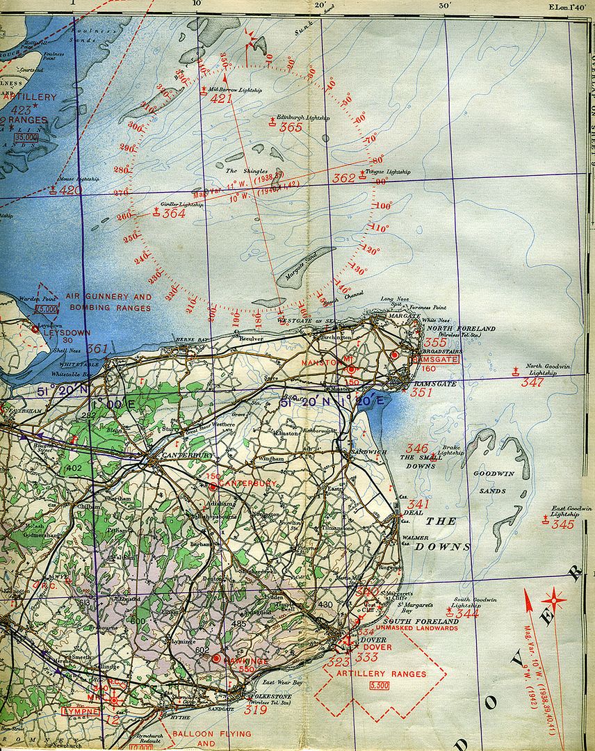    RedToo.
|
|
#8
10-21-2010, 05:37 PM
|
|||
|
|||
|
Now that's more like it! What is that backing though, now I'm all curious.
Edit: I've just completed 2 hrs of internet research and found precious little info. I can only confirm that the 1938 map was used right through the BOB and into 1942. Unfortunately my own library is more ground-battle oriented. Last edited by BadAim; 10-21-2010 at 05:39 PM.
|
|
#9
10-21-2010, 07:35 PM
|
||||
|
||||
|
Quote:
The backing is a mesh of fine threads at right angles to each other. Each thread is like a thread of fine white cotton. The width of the gap between each thread varies between 1 and 1 1/2 millimetres (approximately). RedToo.
|
|
#10
10-21-2010, 05:40 PM
|
||||
|
||||
|
Quote:
Seriously, print this map on the the thickest paper you can find that is not too white and smooth and it will be great!
|
|
| Thread Tools | |
| Display Modes | |
|
|








 Hybrid Mode

