
|
|
|||||||
| IL-2 Sturmovik The famous combat flight simulator. |
 |
|
|
Thread Tools | Display Modes |
|
#71
 12-29-2009, 01:15 PM
|
|||
|
|||
|
Quote:
Thank you! 
|
|
#72
12-29-2009, 01:18 PM
|
|||
|
|||
|
Quote:
Its why I told on Russian forum that impossible to use directly sattelite maps for 1940-45 years action. The goal is to get it close look like photo realistic, like it was, but not like it is now.
|
|
#73
12-29-2009, 01:21 PM
|
|||
|
|||
|
Quote:
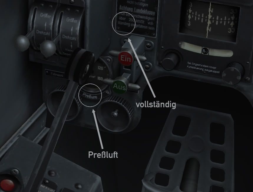
Later I will post high resolution detailed shots. So anybody may help to corect bugs of such king if is. My guys simply copy-repaint such tables from the photos, however not all photos are useful quality or usable on th full square.
|
|
#74
12-29-2009, 02:00 PM
|
||||
|
||||
|
So Oleg, what date do you think for release, everything looks so good like almost done...a quess as to a date would be good enough for now
__________________
 GigaByteBoard...64bit...FX 4300 3.8, G. Skill sniper 1866 32GB, EVGA GTX 660 ti 3gb, Raptor 64mb cache, Planar 120Hz 2ms, CH controls, Tir5
|
|
#75
12-29-2009, 04:30 PM
|
||||
|
||||
|
Don't forget to send copies to reviewers when ready for release.
UH, OH, and a question: Will there be something like physical realistic model of planes crashing to the ground? Please, I love to watch realistic crashes!!!
__________________

Last edited by Alien; 12-29-2009 at 08:07 PM.
|
|
#78
01-04-2010, 11:55 AM
|
|||
|
|||
|
Hey Oleg,first of all i wish to say happy new year (с новый годом, i think it's spelled that way correct me if i'm wrong i studied russian only for 3 years xD).
Second i've been playing il-2 for like 8 years now,and i'm thrilled to see a new flight sim with such detail. But i have some questions: I've read lot of technical data and pilot memoars and my question is will you get deformations in the wing and control places in high speed dives(if you remember that's one of the tactics of the germans to get off the spit's with there fabric elevators). Then we get to the planes themselves i saw the AWESOME(!!!!) work on the planes and the part with the used planes with the different stats,ok but what do you get from that in multiplayer? i mean you said you could jump from one plane to another on the ground and will it be passible that you get off a damaged plane,let's say you've got a whole in the wing after a sortie and you jump off it and to another healthy plane on a let's say dogfight map,and in a period of time will the technicians repair that plane and put it for use but when you get on it it will have the stats of the 'used' plane? Then we get to the pilots themselves, Outstanding job on them too, you said that the skins will be by multiple layers and stuff,will you still be able not only to change your face(you said we can do that) but will you be able to add your rank and medals on the skin as well? Oh and last think, when you get injure in IL-2 you just got redish screen, will we have blood in the cockpit and on the pilot himself in SoW? ~S!~ and top work on the game again!!! greetings from Bulgaria
|
|
#79
01-05-2010, 04:15 AM
|
|||
|
|||
|
A Christmas update, finally able to get back and not once but twice!
Thanks for the update. THe ground vehicles look nice! At first I thought Olga was going to be in the game LOL. But you guys should put her in as the rest of you. some really knowledgeable people helping with the German cockpit! Yeah! Props to you! Like the easter egg thing of Santa . . . Mission Santa's Little Helpers: Escort Santa and prevent nightfighters on both sides from getting a shot on him. Mission, Grinch: You must get through Santa's escorts and force his landing. Future forum discussion: In response to: SOW's SANTA = 1946's Lerche, Faster than a speeding bullet, stronger than a locomotive, able to take hits equal to 3 bombers. . . Ok here's a small FAQ on the Santa missions: Guys, IT'S SANTA. Of course his flight modeling is different. HE has to land on a roof top, hence the FM. He can fly through the fog w/out radar and not hit anything, because he has Rudolph! The reason why Santa can take so much damage is the FM treats each reindeer as an engine, therefore each reindeer must be hit. Santa can fly on one deer. Oh and BTW killing Rudolph won't turn off the fog navigation Santa has. Santa disappears from radar / sight / ground clutter too uber / can't find him in the city issues: Remember Santa lands indiscriminantly on residential houses / apartments etc to drop off gifts. You can't catch him in the sky when he does. Santa is too fast / I used AAA and even the ME 163 can't catch him / Santa climbs too quick. The only time where someone b1tched about realism, LOL. Santa FM is fast, he has to fly around the whole world at night. Santa I take damage when coming on Santa's six, and no one is around. Look at the screen shots below. See the green guy in the santa hat? The elves can throw random toys or use BB guns / fire crackers. Santa puts up a good defense. They modelled the reindeer moving up and down, as if they are riding a wave, they porpoise up and down, so you have to time your shots. Santa has a fuel cheat! Santa runs off the spirit of Christmas, so his FM has unlimited fuel checked.
|
|
#80
01-05-2010, 12:26 PM
|
|||
|
|||
|
It is really nice how you do your work! Sretna nova godina
|
|
| Thread Tools | |
| Display Modes | |
|
|


 Linear Mode

