
|
|
#21
 08-26-2016, 07:18 AM
|
|||
|
|||
|
A couple of appetizers on the work done so far (still work in progress)...
RAF Westhampnett 1944+ 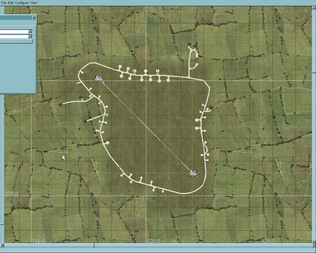 RAF Warmwell 1944+ 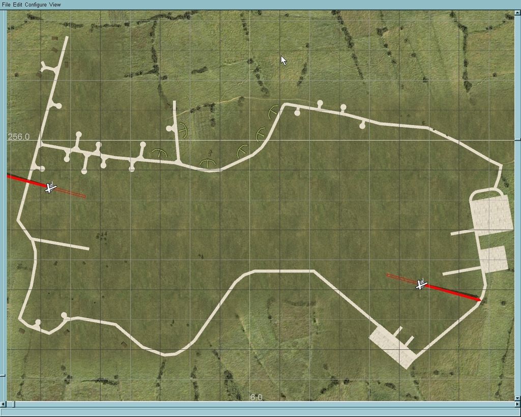
__________________
Last edited by _1SMV_Gitano; 12-12-2016 at 08:24 PM. 
|
|
#23
08-26-2016, 10:54 PM
|
|||
|
|||
|
That's a very ambitious project, particularly if both London and Paris landmarks, as well as the Atlantic Wall defenses around Normandy, are included. It will also be a challenge to get the "White cliffs of Dover" to look right.
I'm assuming that it will be a 1:4 scale map. While they might be separate projects, consider providing a bit more detail to the Cherbourg, Caens, Dunkirk, Dieppe, Le Havre, and St. Lo areas, since they were areas which saw considerable aerial action during the war. On the UK side of the channel, a bit of extra detail in the areas of Dover, Portsmouth, Southampton, and the Isle of Wight (Chain Home Radar stations), as well as the flak defenses in the Thames Estuary would be welcome for BoB missions.
|
|
#24
09-02-2016, 12:43 PM
|
|||
|
|||
|
Looks like this will be one of the best additions ever from TD!
Imagine having Wellingtons, Blenheims or Beauforts for the R.A.F. fans to fly bombing missions over the French coast. And lots of anti-shipping raids for both sides! Anyway...the potential for this map is huge! From the bottom of my heart, THANK YOU VERY MUCH, Team Daidalos for this map and all the rest of your hard work! I, and I'm sure many others with me, really appreciate it!
|
|
#25
09-02-2016, 07:31 PM
|
|||
|
|||
|
Guys, thanks for the kind words!
I would like to share your optimism, but remember such a project is huge and there is alot to be done. For what is worth, map is 1:1 scale, and the plan is to to have several periods, like Solomons and NGNB maps, starting from late August 1944 first and "go back in time".
__________________
|
|
#26
09-02-2016, 07:58 PM
|
|||
|
|||
|
Quote:
Ahem, on a more serious note... I too am very much looking forward to this! Never expected a TD map of this, so regardless of how much time it will take, I am very much excited for this
|
|
#27
09-02-2016, 08:26 PM
|
|||
|
|||
|
Quote:
FWIW, there has been a lot of research done on the WW2 airfields in that part of the world, much of it for other games. It should be possible to get period aerial photographs of most of the Luftwaffe airbases along the English Channel ca. 1940. If you're not already aware of it, this resource might be helpful: http://www.ww2.dk/Airfields%20-%20France.pdf http://www.ww2.dk/lwairfields.html For examples of work done for other games (which might include period maps in the read-me): http://www.sim-outhouse.com/sohforum...ench-airfields http://simviation.com/1/browse-Scenery-79-0 If you're going to be starting from 1944 and working back, also consider adding "Mulberry Harbor" objects, since these would be crucial targets for any hypothetical Luftwaffe counterattack. http://www.combinedops.com/Mulberry%20Harbours.htm Last edited by Pursuivant; 09-02-2016 at 08:31 PM.
|
|
#28
09-02-2016, 09:22 PM
|
|||
|
|||
|
Thanks Pursuivant!
I'm aware of both websites about LW airfields in France, and other material from those websites. My main reference for UK is the excellent series "Military Airfields of Britain" by Ken Delve, plus anything found on the web. Another appetizer: RAF Biggin Hill 1944+ WIP 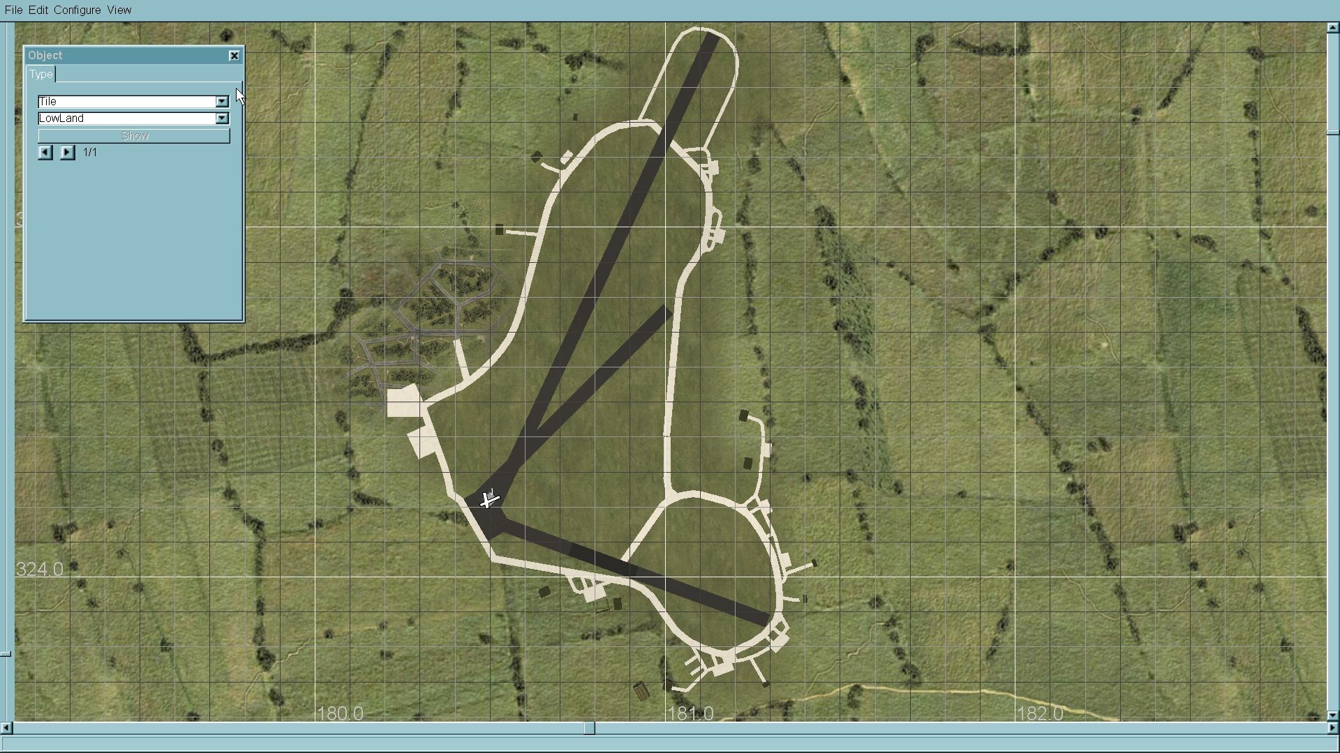
__________________
Last edited by _1SMV_Gitano; 12-12-2016 at 08:25 PM.
|
|
#30
09-05-2016, 08:22 AM
|
|||
|
|||
|
Quote:
Ignoring that, any map of Western Europe is going to be limited by the fact that it's one of the more densely settled places on the planet. That can reduce frame rates to a crawl, even on the best computer. Gitano's Channel Map is already a tremendously ambitious project in that it will need to incorporate not one, but TWO, major world cities and their suburbs, each with their associated landmarks. Plus harbors, coastal defenses, and all the towns, roads, canals, and railroads in between. It would more practical to have a map of England to the Ruhr be its own project. It could be done, since the distance from the SW coast of England to the Ruhr is less than 300 miles, but to limit the scope and size of the project, it would make sense to have the map be a long, narrow rectangle. The north edge of the map could stretch from Ipswich to Munster, and the southern edge could stretch from Canterbury to Dortmund.
|
 |
|
|


 Linear Mode

