Fulqrum Publishing Home   |   Register   |   Today Posts   |   Members   |   UserCP   |   Calendar   |   Search   |   FAQ

Go Back   Official Fulqrum Publishing forum > Fulqrum Publishing > IL-2 Sturmovik

IL-2 Sturmovik The famous combat flight simulator.

Reply
 
Thread Tools Display Modes
  #21  
Old 10-21-2010, 11:59 AM
DD_crash's Avatar
DD_crash DD_crash is offline
Approved Member
 
Join Date: Oct 2007
Location: Buckley North Wales
Posts: 307
Default

Quote:
Originally Posted by RedToo View Post
I have a 1930's RAF map of the south east of England. It is paper on open weave linen. I am at work at the moment. I will post more details when I get home.

RedToo.
Old time (1950s) Ordenance Survey maps used to be paper backed with linen. I dont think that things would have changed much in 10 years.
Reply With Quote
  #22  
Old 10-21-2010, 12:00 PM
Spudkopf's Avatar
Spudkopf Spudkopf is offline
Approved Member
 
Join Date: Nov 2007
Location: Australia
Posts: 248
Default

Didn't the Germans just use the Michelin Guide?
__________________
Spud

Reply With Quote
  #23  
Old 10-21-2010, 01:06 PM
W32Blaster W32Blaster is offline
Approved Member
 
Join Date: Feb 2010
Posts: 83
Default

... always used secret weapon:

google maps

Reply With Quote
  #24  
Old 10-21-2010, 01:18 PM
FG28_Kodiak FG28_Kodiak is offline
Approved Member
 
Join Date: Dec 2009
Location: Swabia->Bavaria->Germany
Posts: 884
Default

Luft Navigationskarte Deutschland 1938 (Air Navigation Map Germany 1938 ):
http://www.cockpitinstrumente.de/dow...Europa1938.htm

Last edited by FG28_Kodiak; 10-21-2010 at 01:24 PM.
Reply With Quote
  #25  
Old 10-21-2010, 01:33 PM
ECV56_Lancelot ECV56_Lancelot is offline
Approved Member
 
Join Date: Oct 2009
Location: Argentina
Posts: 225
Default

I beleive people are missing the point here, the problem is not the map since they already have it, the problem its the printing and the paper/plastic to use. And also the problem its make the printing that look like a BoB era map.

Luthier, i cant help on this, but i don't know if you have good relations with Eagle Dynamics, because you could talk to them since they released a printed map for DCS Black Shark of the Kuban area to be availabe as an extra purchase. They maybe could give a hint in the right direction.
Just a thought!
Reply With Quote
  #26  
Old 10-21-2010, 01:56 PM
winny winny is offline
Approved Member
 
Join Date: Sep 2009
Location: Manchester UK
Posts: 1,508
Default

British Escape maps were originally printed on silk (that was deemed unfit for parachutes) as silk became rarer they later printed them on Rayon.

They used pectin mixed with the ink which stopped bleed.

They also printed some on tissue.

Here's an early bartholomew Map


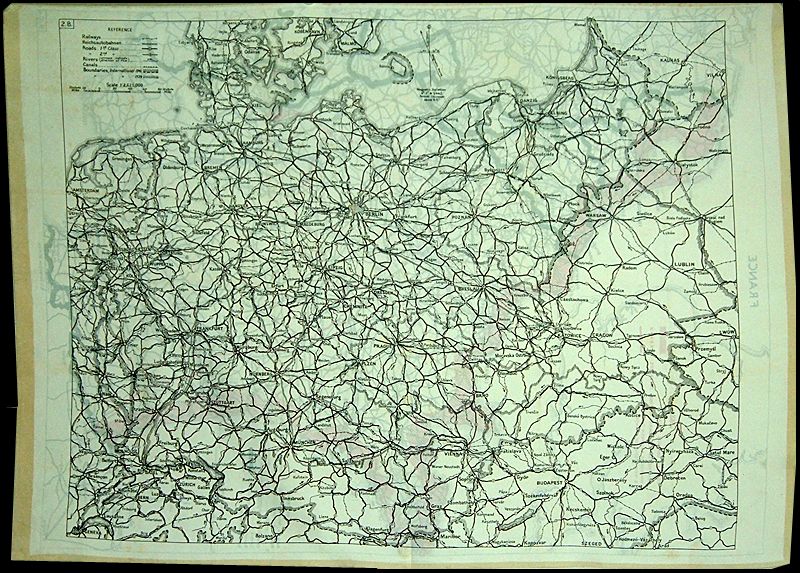
Got most of the info from here

The actual pilot's map was usually printed on heat treated paper but this varied from country to country.
Reply With Quote
  #27  
Old 10-21-2010, 01:59 PM
NSU's Avatar
NSU NSU is offline
Approved Member
 
Join Date: Oct 2007
Location: Heidelberg_Germany
Posts: 251
Default

Hi Luthier

you see the Maps from the Desastersoft IL2 Add-on?


Reply With Quote
  #28  
Old 10-21-2010, 02:29 PM
speculum jockey
Guest
 
Posts: n/a
Default

There seems to be some sort of Communication Breakdown going on here. Let's take a closer look at Luthier's post and see if we can discern the secret meaning.

Quote:
Originally Posted by luthier View Post
Hello everyone,
What exact material were the common pilot maps printed out for RAF and Luftwaffe in 1940?
Hmmm. . . pretty complicated,. Let's cut out some of the unnecessary stuff.

Quote:
Originally Posted by luthier View Post
What exact material were the common pilot maps printed
Almost there!

Quote:
Originally Posted by luthier View Post
What exact material
Perfect!

What Material? As in what did they print the maps on?

a. Paper
b. Laminated paper
c. Rayon
d. The pilot's arm (tattoo)
e. Silk
f. Nylon
g. Deli meats

They are not asking you what to put on the maps, they are asking what to put the maps on!

Things they don't need:

Maps from AFTER the Battle of Britain.
Non-Pilot maps. (maps not used by pilots)
Pictures of the Map's Content.
Incredibly off-topic Italian Babbling about post-war maps.

If you don't know what the maps were printed on, then posting a picture of 1943 Poland is not going to help.

Personally, I'm probably going to rule out silk/rayon/nylon or any other fabric since the pilots didn't need to hide their flight maps and required something foldable but semi-rigid so they could see it properly. Take a tissue, draw a picture on it, then try and read it with one hand. Odd are, the material they are looking for is some manner of paper/laminated paper, or card-stock.
Reply With Quote
  #29  
Old 10-21-2010, 02:34 PM
NSU's Avatar
NSU NSU is offline
Approved Member
 
Join Date: Oct 2007
Location: Heidelberg_Germany
Posts: 251
Default

The Luftwaffe Briefing Room Map is made of Paper, some Maps are carton
for the Pilot is made of linen cloth and rubber (yellow Luftwaffe maps).

Last edited by NSU; 10-21-2010 at 02:55 PM.
Reply With Quote
  #30  
Old 10-21-2010, 02:41 PM
Drum_tastic Drum_tastic is offline
Approved Member
 
Join Date: Aug 2008
Posts: 53
Default

Quote:
Originally Posted by speculum jockey View Post
There seems to be some sort of Communication Breakdown going on here. Let's take a closer look at Luthier's post and see if we can discern the secret meaning.


Hmmm. . . pretty complicated,. Let's cut out some of the unnecessary stuff.


Almost there!


Perfect!

What Material? As in what did they print the maps on?

a. Paper
b. Laminated paper
c. Rayon
d. The pilot's arm (tattoo)
e. Silk
f. Nylon
g. Deli meats

They are not asking you what to put on the maps, they are asking what to put the maps on!

Things they don't need:

Maps from AFTER the Battle of Britain.
Non-Pilot maps. (maps not used by pilots)
Pictures of the Map's Content.
Incredibly off-topic Italian Babbling about post-war maps.

If you don't know what the maps were printed on, then posting a picture of 1943 Poland is not going to help.

Personally, I'm probably going to rule out silk/rayon/nylon or any other fabric since the pilots didn't need to hide their flight maps and required something foldable but semi-rigid so they could see it properly. Take a tissue, draw a picture on it, then try and read it with one hand. Odd are, the material they are looking for is some manner of paper/laminated paper, or card-stock.
Lol, love it!
Reply With Quote
Reply


Posting Rules
You may not post new threads
You may not post replies
You may not post attachments
You may not edit your posts

BB code is On
Smilies are On
[IMG] code is On
HTML code is Off

Forum Jump


All times are GMT. The time now is 07:07 AM.


Powered by vBulletin® Version 3.8.4
Copyright ©2000 - 2024, Jelsoft Enterprises Ltd.
Copyright © 2007 Fulqrum Publishing. All rights reserved.