Fulqrum Publishing Home   |   Register   |   Today Posts   |   Members   |   UserCP   |   Calendar   |   Search   |   FAQ

Go Back   Official Fulqrum Publishing forum > Fulqrum Publishing > IL-2 Sturmovik: Cliffs of Dover > Technical threads > FM/DM threads

FM/DM threads Everything about FM/DM in CoD

Reply
 
Thread Tools Display Modes
  #51  
Old 09-22-2012, 09:36 AM
NaBkin's Avatar
NaBkin NaBkin is offline
Approved Member
 
Join Date: Mar 2011
Posts: 58
Default

Quote:
Originally Posted by IvanK View Post
Yes you should be able to calculate the wind Direction from the Trk and groundspeed. Though shudder at the possibility that wind input will use the Russian penchant to use were the wind is blowing to rather than the aviation standard of where it is coming from .... just leads to more forum discussion ambiguities. This directional thing has been discussed directly with Ilya a long time ago so hopefully its not an issue, though wind directional input is still some weird Angle expression rather than a straight Bearing !

In general terms we know its a "Northerly"

I will get my "prayer wheel' out and start doing some vectors.

Good idea on setting it to zero rather than just deleting it.
Could you still do my 3min / 250kmh test? I just dont see what I did different and get rather 'incorrect' data.
Thanks
Reply With Quote
  #52  
Old 09-22-2012, 12:31 PM
NaBkin's Avatar
NaBkin NaBkin is offline
Approved Member
 
Join Date: Mar 2011
Posts: 58
Default

Quote:
Originally Posted by IvanK View Post
Edit from first post found an Ooops in the calcs ... corrected made error even less. I deleted the original post and re post here.

Here is my contribution in trying to sort this perceived issue out. Happy for anyone to pull apart and destroy my method,calculations and or assumptions.

SPEED TEST METHOD
Picked 2 easily seen landmarks far enough apart to provide reasonable distance.
2 landmarks chosen Dungeness point lighthouse and Capr Griz Nez.
Then measured actual real world distance in Google maps 42.59Km


Next in CLOD FMB established map Grid size via X coordinates between two adjoining vertical grid lines. This was 10,000 metres.

In FMB set up BF109 at 10m over Dungenes point at 0700 hrs at 420Kmh.
Set Destination Waypoint Griz Nez at 420Kmh.
FMB Computed Time interval 6min.
at 6min 420Kmh gives 42Km ... Close enough to real world distance.
Conclusion CLOD map is 1:1, OK to use for time Distance Speed checks.


Set up Ships along the planned track to allow for easy navigation.

Next Flew the course 4 times 2 East bound and 2 Westbound to ensure
the cancellation of any hidden/latent winds on the map. (just as well)

Each run commenced inland of the initial waypoint at Sea level Stabilised on speed 420Kmh IAS Wings level in Trim.
Stop watch started over First waypoint and stopped over end waypoint
IAS maintained +-5Kmh throughout using Wonder woman mode Large ASI.

RESULTS:
SE Bound Run1 Elapsed time 5:25
SE Bound Run 2 Elapsed time 5:23
NW Bound Run 1 Elapsed time 6:25
NW Bound Run 2 Elapsed time 6:18
(Average West bound runs take 57secs longer)
Total Time 23min 51 secs

Given the consistent significant diff between SE and NW runs I can only conclude
that there is some hidden wind (or retroverted Coriolis) on the base map. Runs in both directions will negate Wind affect if results are averaged.

Using Real World distances. 42.59Km X 4 = 170.36Km
170.36Km at 420Kmh would take 24min 20secs
I achieved in CLOD test 23min 51 secs.

So over say 23mins 51secs the diff was 29 seconds
Over 1 hr the difference would be 73 seconds
73 seconds at 420Kmh equates to 8.51Km
Experimental speed error 8.51Kmh i.e. about 2.0%

Considering all the various potential errors in the methodology:
Google map distance measurement
CLOD FMB map accuracy
Exact Stopwatch activation location
Slight IAS piloting errors
Assuming IAS=TAS at Sea level (which we know is close but not exact)
a 2.0% or in real numbers 8.5 kmh variance is insignificant .
Conclusion Displayed BF109E4 IAS is accurate.

NOTES
Be careful using timed runs over geographic features as some hidden wind is IMO resident on the base map. Flying the track both ways and averaging the results should cancel out the wind effect.

If you want to test the RAF types then the target IAS based on Statue mile would be 261MPH.

Test Mission file attached


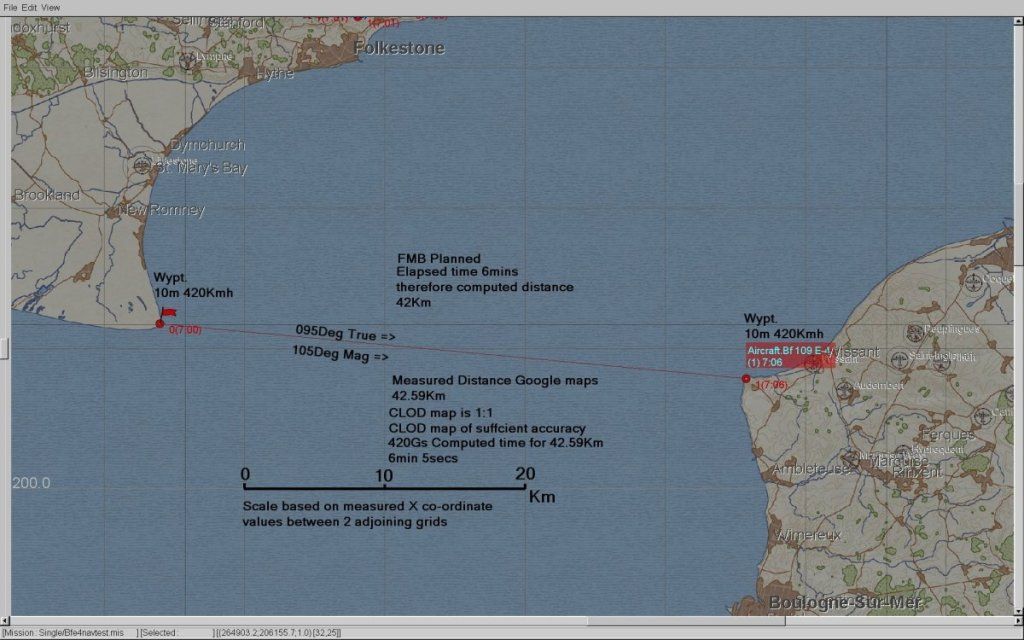
OK today I did the almost exact test as you did (my way to travel was 41.8Km from point to point).


Here are my results (no wind, 500m):

From France to GB, 300km/h, 41.8km:

-> estimated time: 8min 21sec

G.50 = 7min 37sec = 44sec difference
He 111H = 7min 18sec = 1min 3sec difference


From GB to France, 300km/h, 41.8km:

G.50 = 7min 00sec = 1min 21sec difference
He 111H = 6min 48sec = 1min 33sec difference

So both planes fly faster from GB to F (37sec the G.50 and 30sec the He111)

Again, its not very bad but its a difference considering its done in an "laboratory environment" . However its not as bad as my first testing which was done almost exactely from E - W (260 degrees).

To me it seems that
- theres some kind of "secret wind" (considering the difference between GB-F, F-GB)
or
- the gauges dont work proper (considering the difference between He111 - G.50)


And here my one way testing results from earlier:
(no wind, HDG 260deg, 100m alt, 3min fliying time)

Me110 C7: 248km/h (gauge) for 3min = 14km
actual distance: 12,4. Difference = 1,6km

Me1109E3: 250km/h (gauge) for 3min = 14,2km
actual distance: 12,5. Difference = 1,7km

SpitIa: 222km/h (138mph gauge) for 3min = 13,8km
actual distance: 11,1. Difference = 2,7km

Hurri (Rotol): 206km/h (128mph gauge) for 3min = 13,3km
actual distance: 10,3. Difference = 3,0km

He111H: 248km/h (gauge) for 3min = 14,4km
actual distance: 12,4. Difference = 2,0km

Last edited by NaBkin; 09-22-2012 at 12:37 PM.
Reply With Quote
  #53  
Old 09-22-2012, 12:51 PM
IvanK IvanK is offline
Approved Member
 
Join Date: Oct 2007
Location: Australia
Posts: 886
Default

I suggest you do everything at sea level. 500m is to high it introduces a real difference between Indicated Airspeed (IAS) and True Air Speed (TAS). Doing the test at sea level pretty much eliminates this as IAS is very close to TAS.

I don't see any correction in your results for TAS. 500m Altitude on a Standard day would result in around 6Kmh diff between IAS and TAS.

I will have a look at 3min test like yours but at sea level only. Personally I think 3 mins is too short a time period and magnifies any errors. You also need to always fly the test both ways to ensure cancellation of any wind effects. In addition I think you would be better off doing ALL your tests between to fixed markers a known distance apart rather than flying a time and seeing where you end up. There are issues transferring your perceived position to the map then measuring.

Nothing to stop you precisely placing Ships at 10000m intervals using the Grid on the FMB map and using this as a test track. Timing between features a known distance apart is the way to go imo.

Last edited by IvanK; 09-22-2012 at 10:46 PM.
Reply With Quote
  #54  
Old 09-23-2012, 03:51 PM
ACE-OF-ACES's Avatar
ACE-OF-ACES ACE-OF-ACES is offline
Approved Member
 
Join Date: May 2010
Location: NM
Posts: 2,248
Default

Quote:
Originally Posted by NaBkin View Post
You are right, talk is cheap. So don't talk, act!
Way ahead of ya.. www.flightsimtesting.com
__________________
Theres a reason for instrumenting a plane for test..
That being a pilots's 'perception' of what is going on can be very different from what is 'actually' going on.
Reply With Quote
  #55  
Old 09-23-2012, 10:38 PM
ACE-OF-ACES's Avatar
ACE-OF-ACES ACE-OF-ACES is offline
Approved Member
 
Join Date: May 2010
Location: NM
Posts: 2,248
Default

Quote:
Originally Posted by SlipBall View Post
I think KG_26 Alpha pointed out that the developers are aware of the gauge problem.
True..

Which is just another good reason to not rely solely on the gauges!

Best to use some of the C# scripts aval (FST has one and klem has one based on FST's with some added features) that collect data in real time.

And not only the gauge values (I_*), but the internal game 3D world values (Z_*).

In the testing I have done so far, I have found the gauge values (I_*) to not only be off, but laggy and with offsets.

Where as most (not all) of the internal game 3D world values (Z_*), thus far, seem to match the real world data better.

On that note

All the game calculations are done using the internal game 3D world values (Z_*), the gauge values are derived from these. When I say derived, I mean they may add code to them to make them mimic real world gauges (laggy, offsets, etc)

Hope that helps!
__________________
Theres a reason for instrumenting a plane for test..
That being a pilots's 'perception' of what is going on can be very different from what is 'actually' going on.
Reply With Quote
  #56  
Old 09-23-2012, 10:56 PM
ACE-OF-ACES's Avatar
ACE-OF-ACES ACE-OF-ACES is offline
Approved Member
 
Join Date: May 2010
Location: NM
Posts: 2,248
Default

Quote:
Originally Posted by JtD View Post
I appreciate the information shared by those who take the time and make the effort to actually test in game performance. Very much.)
Your welcome!

But to be honest.. Doing the test is not a big deal.. Anyone can test an in game plane..

But I will say this, very few take the time to do the research on how the tests were actually performed during WWII to ensure the test method and plane configuration used in game is as close as it can be to the actual WWII test data.. That and I am the only one I know of, thus far, that has not only gone as far as to make the effort to actually test the plane performance, but also gone as far as to provided the tools to compare/graph the game results along side the real world results..

Which can be seen at my website, i.e.

www.flightsimtesting.com
__________________
Theres a reason for instrumenting a plane for test..
That being a pilots's 'perception' of what is going on can be very different from what is 'actually' going on.

Last edited by ACE-OF-ACES; 09-23-2012 at 10:58 PM.
Reply With Quote
  #57  
Old 09-24-2012, 09:30 AM
klem's Avatar
klem klem is offline
Approved Member
 
Join Date: Nov 2007
Posts: 1,653
Default

Quote:
Originally Posted by ACE-OF-ACES View Post
True..

Which is just another good reason to not rely solely on the gauges!

Best to use some of the C# scripts aval (FST has one and klem has one based on FST's with some added features) that collect data in real time.

And not only the gauge values (I_*), but the internal game 3D world values (Z_*).

In the testing I have done so far, I have found the gauge values (I_*) to not only be off, but laggy and with offsets.

Where as most (not all) of the internal game 3D world values (Z_*), thus far, seem to match the real world data better.

On that note

All the game calculations are done using the internal game 3D world values (Z_*), the gauge values are derived from these. When I say derived, I mean they may add code to them to make them mimic real world gauges (laggy, offsets, etc)

Hope that helps!
AoA would you look at some of your Z_IAS, Z_TASs and corresponding Altitude figures and give me your view. It seems to me that the Z_IAS and Z_TAS are too close together at altitude. I'd like to get another opinion.

Just playing with the numbers, I found that if I took the Z_TAS and the TAS roughly calculated from IAS (cockpit gauge) for altitude (~2% per 000ft) they weren't very far apart whereas the Z_IAS and IAS (cockpit) were a long way apart.

It left me wondering if perhaps IAS (cockpit) is derived from Z_TAS (with maybe a few more accurate atmosphere adjustments)
__________________
klem
56 Squadron RAF "Firebirds"
http://firebirds.2ndtaf.org.uk/


ASUS Sabertooth X58 /i7 950 @ 4GHz / 6Gb DDR3 1600 CAS8 / EVGA GTX570 GPU 1.28Gb superclocked / Crucial 128Gb SSD SATA III 6Gb/s, 355Mb-215Mb Read-Write / 850W PSU
Windows 7 64 bit Home Premium / Samsung 22" 226BW @ 1680 x 1050 / TrackIR4 with TrackIR5 software / Saitek X52 Pro & Rudders
Reply With Quote
  #58  
Old 09-24-2012, 03:21 PM
ACE-OF-ACES's Avatar
ACE-OF-ACES ACE-OF-ACES is offline
Approved Member
 
Join Date: May 2010
Location: NM
Posts: 2,248
Default

Quote:
Originally Posted by klem View Post
AoA would you look at some of your Z_IAS, Z_TASs and corresponding Altitude figures and give me your view. It seems to me that the Z_IAS and Z_TAS are too close together at altitude. I'd like to get another opinion.
Agreed 100%

Bare with me here, in that it was well over a year ago that I started looking at the CoD data.. And from what I recall, the Z IAS value made no since.. If I recall correctly, it had the same shape and values of the Z TAS, only with a little bit of an offset. There were also some issues with the I vs Z ROC value (Z TAS 3).. I recall taking the derivative of the Altitude, both I and Z and recall one of them making since, and the other not. There were a few more that were not what I was expecting, I would have to check my notes. So, all in all there are some issues with the Z values. Hopefully one of these days 1C will provide a read me that explains what they are such that we don't have to guess what they are!

On that note, due to these unknowns, my plan to leave the choice as to which value to use up to the users when using my CoD analysis tools at my web site
__________________
Theres a reason for instrumenting a plane for test..
That being a pilots's 'perception' of what is going on can be very different from what is 'actually' going on.

Last edited by ACE-OF-ACES; 09-24-2012 at 03:30 PM.
Reply With Quote
  #59  
Old 09-24-2012, 09:17 PM
Crumpp's Avatar
Crumpp Crumpp is offline
Approved Member
 
Join Date: Feb 2008
Posts: 1,552
Default

WWII flight testing for the most part was not sophisticated.

Quote:
Tagert says:
very few take the time to do the research on how the tests were actually performed during WWII
The first thing done in WWII flight testing is airspeed calibration by flying know points on the ground.

If you did that, you would know this issue.
__________________
Reply With Quote
  #60  
Old 09-25-2012, 02:29 PM
ACE-OF-ACES's Avatar
ACE-OF-ACES ACE-OF-ACES is offline
Approved Member
 
Join Date: May 2010
Location: NM
Posts: 2,248
Default

Quote:
Originally Posted by Crumpp View Post
WWII flight testing for the most part was not sophisticated.
That is your opinion and your welcome to it..

And yes we have established the fact that you belive you know more than the test engineers and pilots who preformed these tests and flew these planes in WWII..

We get it!

And just to be crystal clear..

Nobody here is saying that it is NOT ok for you to belive that!

All I and others are asking of you is that you don't take it personal when I and others don't agree with your self assessment

Thanks in advance! S!
__________________
Theres a reason for instrumenting a plane for test..
That being a pilots's 'perception' of what is going on can be very different from what is 'actually' going on.
Reply With Quote
Reply


Posting Rules
You may not post new threads
You may not post replies
You may not post attachments
You may not edit your posts

BB code is On
Smilies are On
[IMG] code is On
HTML code is Off

Forum Jump


All times are GMT. The time now is 01:54 AM.


Powered by vBulletin® Version 3.8.4
Copyright ©2000 - 2025, Jelsoft Enterprises Ltd.
Copyright © 2007 Fulqrum Publishing. All rights reserved.