Fulqrum Publishing Home   |   Register   |   Today Posts   |   Members   |   UserCP   |   Calendar   |   Search   |   FAQ

Go Back   Official Fulqrum Publishing forum > Fulqrum Publishing > IL-2 Sturmovik: Cliffs of Dover > Gameplay questions threads

Gameplay questions threads Everything about playing CoD (missions, tactics, how to... and etc.)

Reply
 
Thread Tools Display Modes
  #41  
Old 04-27-2011, 11:47 AM
IvanK IvanK is offline
Approved Member
 
Join Date: Oct 2007
Location: Australia
Posts: 886
Default

Quote:
Originally Posted by JVM View Post
On this I can certainly help you as I have the full 1940 French railway system of the game area (and even a bit more as the latter has slightly decreased since the original idea of MG) as a kml file.

I have separated the standard gauge system, the 1 m gauge system and the specific German military system developed for the big guns.

You should know however as far as France is concerned that most probably a very small part of the standard system is shown in-game, and most probably the 1 m gauge and military are not there at all (for now).

There are also many issues on the map itself, which I hope will be addressed later (like nuclear power plant landscape items, or 1975 harbors...things like that; some airfields are not completely well placed, and three of them should not exist at all. Some names are not spelled properly, and there are many other issues (devs are aware of all this, but corrections are certainly not a priority for now )

Let me know if I can do something for you (if you know how to convert a kml to a string of map positions, it might help if your map can be geo-referenced)!

JVM
Thanks for the offer JVM. I have no idea how to Geo Refrence the map. Do you have a simple graphical plot of the railways or is it all in data ?
Reply With Quote
  #42  
Old 04-27-2011, 12:49 PM
JVM JVM is offline
Approved Member
 
Join Date: Oct 2007
Posts: 188
Default

Hello Ivan!

As a kml it is all in data. However you can select the line(s) you are interested in, display it on Google Earth and save the image in such a way that the totality of the line is visible as well as some landmarks: after that you can scale it in a Photoshop layer and either extract it as a color, or copy it manually.
I had to reproduce manually all the details (the track layout precision is usually better than 1 meter...) as this data is intended for the in-game landscape, but for a navigational map you can afford to be less intricate, so the manual reproduction method above should be quite OK.

JV
Reply With Quote
  #43  
Old 04-29-2011, 01:25 AM
xnomad xnomad is offline
Approved Member
 
Join Date: Jul 2010
Location: Sydney, Australia
Posts: 265
Default

Hi Guys,

I've taken Wooster's map and put it in PDF format. It's 3 pages wide and 4 pages long (A4) So 12 pages large.

http://www.megaupload.com/?d=V6JDRVQN

I was messing about with margins but didn't' have time, so there's a tiny bit of white space between the pages, but you can just cut these off or fold them.

I used posterazor on Ubuntu to generate the PDF.
Reply With Quote
  #44  
Old 04-29-2011, 10:10 AM
Moggy's Avatar
Moggy Moggy is offline
Approved Member
 
Join Date: Jun 2010
Posts: 272
Default

Just a quick FYI (I'm sure you're already aware of this), with the new beta patch there is now a lot more detail on the map with more towns being named and a few new airfields like Westhampnett, the satellite airfield for Tangmere.
__________________
Keep calm and carry on

http://www.tangmerepilots.co.uk/
Reply With Quote
  #45  
Old 08-22-2011, 10:25 AM
jcenzano's Avatar
jcenzano jcenzano is offline
Approved Member
 
Join Date: Jan 2011
Location: Spain
Posts: 159
Default

sorry to come back to this old post but I was wondering if there has been any new work made on these printable maps,

thanks to the guys who have put a lot of time and effort on them.
__________________
Intel i7-2600K // Asus Maximus IV Extreme Rev3 // 2xGTX580-3GB (SLI'ed when able) // 16 GB DDR3 // SSD // HDD WD 10K // Win7 x64 // LG monitor 24´´ 1920x1200 res
Reply With Quote
  #46  
Old 10-04-2011, 04:51 PM
Nanba sempai Nanba sempai is offline
Registered Member
 
Join Date: Oct 2011
Posts: 1
Default

Quote:
Originally Posted by Jarsalla View Post
Using a tool called posterazor http://posterazor.sourceforge.net/ you can make a big map out of the map Wooster posted with a regular A4 or A3 capable printer. I just did it, now I just have to glue all the pages together
Thanks for the link! But there are many programs of this category, for example, I use this poster making software.
Reply With Quote
  #47  
Old 10-04-2011, 10:55 PM
major_setback's Avatar
major_setback major_setback is offline
Approved Member
 
Join Date: Oct 2007
Location: Lund Sweden
Posts: 1,415
Default

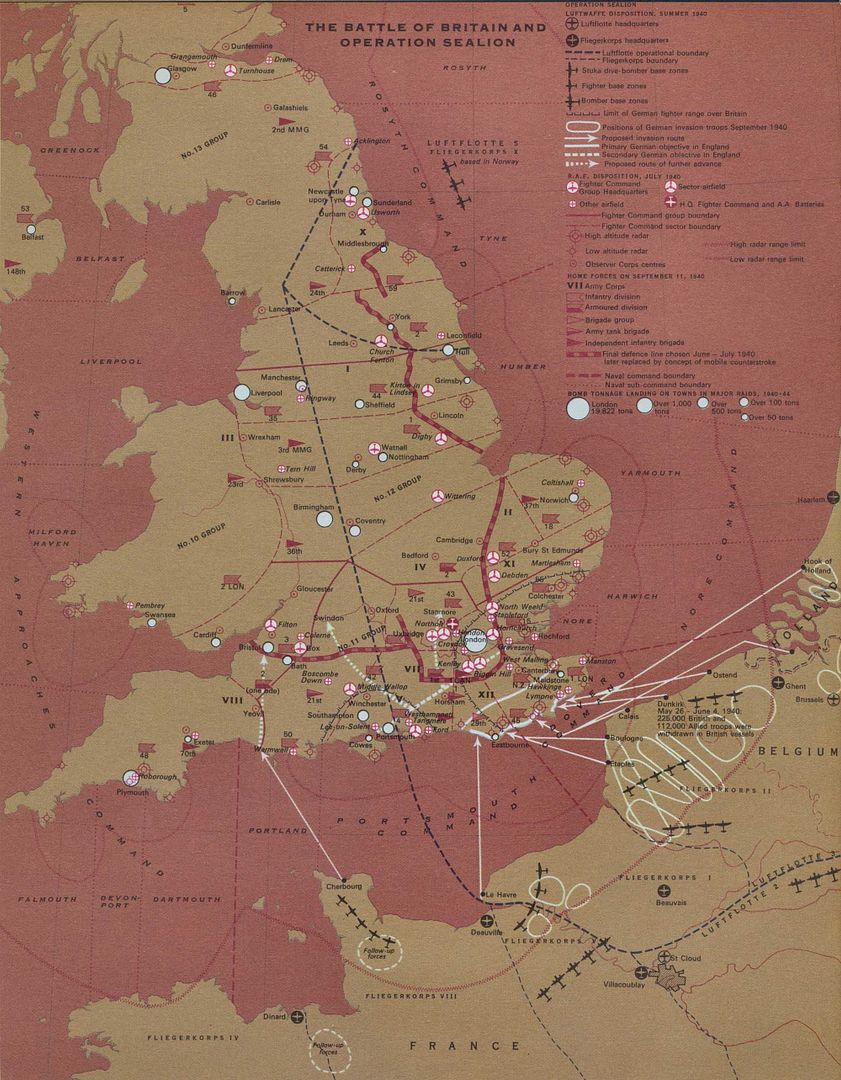
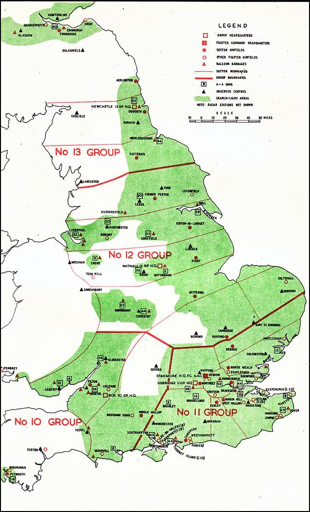
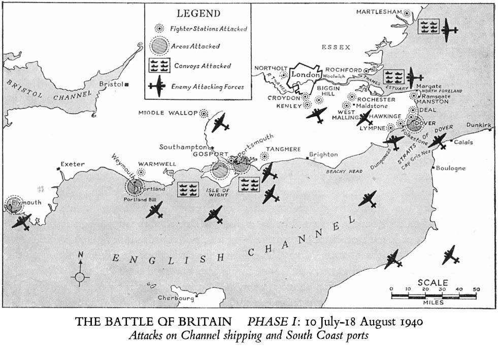
Here, these might be useful:


__________________
All CoD screenshots here:
http://s58.photobucket.com/albums/g260/restranger/

__________


Flying online as Setback.
Reply With Quote
  #48  
Old 10-05-2011, 04:31 AM
Al Schlageter Al Schlageter is offline
Approved Member
 
Join Date: Oct 2007
Posts: 657
Default

Pas de Calais area
http://don-caldwell.we.bs/jg26/pdecal.htm

France/Holland/Belgium
http://don-caldwell.we.bs/jg26/frholbel.htm

RAF Airfields - South East England
http://don-caldwell.we.bs/jg26/engmap.htm

German airfields with grid references
http://don-caldwell.we.bs/jg26/gradnetz.htm
Reply With Quote
  #49  
Old 10-05-2011, 08:47 AM
JVM JVM is offline
Approved Member
 
Join Date: Oct 2007
Posts: 188
Talking

Quote:
Originally Posted by Al Schlageter View Post
Pas de Calais area
http://don-caldwell.we.bs/jg26/pdecal.htm

France/Holland/Belgium
http://don-caldwell.we.bs/jg26/frholbel.htm

RAF Airfields - South East England
http://don-caldwell.we.bs/jg26/engmap.htm

German airfields with grid references
http://don-caldwell.we.bs/jg26/gradnetz.htm
Beware of this data...it is of no use whatsoever (except explanations of planquadrat in the last link).
Most of the locations were made using darts from 10 yards away, and 2/3 of them are not even designating airfields. If you want real locations, tell me, I will send a kmz file.
Even MG who had this kmz file made some slight positioning mistakes, but admittedly small and not too many...
MG serious airfield errors are of a different nature (runways/L_T/O directions were none really existed, and usually not even representative of preferred axises, wrong shapes, haphazard hangar locations, no clear boundaries etc etc). Hopefully a revision will be possible later...

JVM
Reply With Quote
  #50  
Old 01-23-2012, 08:36 AM
klem's Avatar
klem klem is offline
Approved Member
 
Join Date: Nov 2007
Posts: 1,653
Default

IvanK

did your map ever get completed and can we get it somewhere?

btw, I notice that Wooster's link and a couple of others on the back of it are the subject of anti-piracy action by the US Govt.
__________________
klem
56 Squadron RAF "Firebirds"
http://firebirds.2ndtaf.org.uk/


ASUS Sabertooth X58 /i7 950 @ 4GHz / 6Gb DDR3 1600 CAS8 / EVGA GTX570 GPU 1.28Gb superclocked / Crucial 128Gb SSD SATA III 6Gb/s, 355Mb-215Mb Read-Write / 850W PSU
Windows 7 64 bit Home Premium / Samsung 22" 226BW @ 1680 x 1050 / TrackIR4 with TrackIR5 software / Saitek X52 Pro & Rudders
Reply With Quote
Reply


Posting Rules
You may not post new threads
You may not post replies
You may not post attachments
You may not edit your posts

BB code is On
Smilies are On
[IMG] code is On
HTML code is Off

Forum Jump


All times are GMT. The time now is 08:41 PM.


Powered by vBulletin® Version 3.8.4
Copyright ©2000 - 2024, Jelsoft Enterprises Ltd.
Copyright © 2007 Fulqrum Publishing. All rights reserved.