
|
|
#11
 06-05-2012, 01:27 PM
|
||||
|
||||
|
Quote:
__________________

|
|
#12
06-05-2012, 02:38 PM
|
|||
|
|||
|
Thats going in my sig...
|
|
#13
06-05-2012, 04:54 PM
|
||||
|
||||
|
Quote:
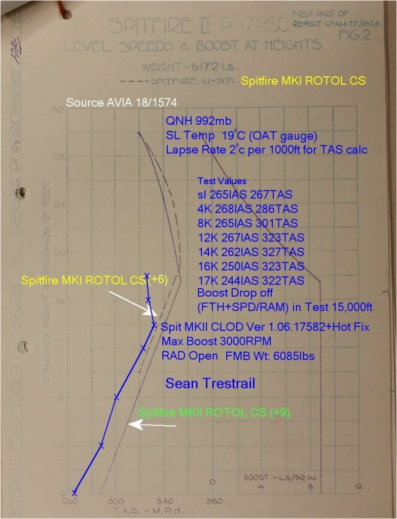
Ballparking it off the data you gave I get your Density Altitude at 14000 feet as ~15500 ft. It looks like the FTH then is ~1000 feet low and the aircraft is about 3% off in SL Vmax. |
|
#14
06-05-2012, 04:58 PM
|
||||
|
||||
|
Quote:
In my own created server and in ATAG I find the correct setting 'on line' for Tangmere (which is about 39feet) is 995mb. Based on that I set 995 at Manston and get 140 feet in both servers. IOn off-line single mission Free Flight over England after landing Manston I have to set 996 to get 140 feet. So different types of 'day' perhaps?
__________________
klem 56 Squadron RAF "Firebirds" http://firebirds.2ndtaf.org.uk/  ASUS Sabertooth X58 /i7 950 @ 4GHz / 6Gb DDR3 1600 CAS8 / EVGA GTX570 GPU 1.28Gb superclocked / Crucial 128Gb SSD SATA III 6Gb/s, 355Mb-215Mb Read-Write / 850W PSU Windows 7 64 bit Home Premium / Samsung 22" 226BW @ 1680 x 1050 / TrackIR4 with TrackIR5 software / Saitek X52 Pro & Rudders |
|
#15
06-05-2012, 05:02 PM
|
||||
|
||||
|
Maybe that's it, Klem.
Except, the Ia's FM's agree very closely under the exact same test conditions offline vs online. The IIa's FM's do not.
__________________
Last edited by ATAG_Snapper; 06-05-2012 at 05:27 PM. |
|
#16
06-05-2012, 05:16 PM
|
|||
|
|||
|
Me and my wingman often have 200m's defference staring from the same field on our altimeters.
|
|
#17
06-05-2012, 05:21 PM
|
||||
|
||||
|
3% off in SL Vmax?
((267 mph TAS actual - 287 mph TAS spec) x 100)/(287 mph TAS spec) = -7% or am I doing this wrong?
__________________
|
|
#18
06-05-2012, 09:10 PM
|
||||
|
||||
|
Quote:
Both have same baro setting? Reading from the tooltip or the gauge needle? Tooltips are to nearest 100 feet in RAF planes so one a/c at 90 feet and one at 105 feet will read 0 and 100 respectively. Or the 109s are porked and next time I will run from a 109 at 25 feet and see what happens behind me
__________________
klem 56 Squadron RAF "Firebirds" http://firebirds.2ndtaf.org.uk/ ASUS Sabertooth X58 /i7 950 @ 4GHz / 6Gb DDR3 1600 CAS8 / EVGA GTX570 GPU 1.28Gb superclocked / Crucial 128Gb SSD SATA III 6Gb/s, 355Mb-215Mb Read-Write / 850W PSU Windows 7 64 bit Home Premium / Samsung 22" 226BW @ 1680 x 1050 / TrackIR4 with TrackIR5 software / Saitek X52 Pro & Rudders |
|
#19
06-05-2012, 10:37 PM
|
|||
|
|||
|
We both take off and he'll say 2000m's and Ill say what? we are are at 2200. Read from the needle.
|
|
#20
06-05-2012, 10:46 PM
|
|||
|
|||
|
Easiest way to set accurate QNH is set the Altimeter to the field elevation. Field elevation can be found in FMB. Attached file has every airfield's elevation in the Sim all obtained from FMB.
A 1mb error should only result in 30ft/10m error. I do believe the default maps have some diurnal variation in both Temperature and pressure. I too have seen 992mb as the setting on ATAG at some times and 995mb at other times. Last edited by IvanK; 06-05-2012 at 10:54 PM. |
 |
|
|


 Linear Mode

