
|
|
#11
 03-04-2010, 05:14 PM
|
|||
|
|||
|
Dover Harbour
I have travelled through the harbour many times and on one occasion had a detailed visit to the Western Harbour to view the quayside when I was involved with a project to build a new cruise liner quay. Historically most of the foot and vehicle traffic would have gone out through the quays on the eastern harbour. There was facilities here to lift vehicles into ships by crane. No roll on roll off at that time. The western harbour was the train ferry terminal. The terminal building which was a large glazed roof train shed was still there in 1995. There was a roll-on facility for railway rolling stock which may have been pre war -- not sure Anyway you should think in terms of a lot of rail related scenery on the west side. The rear part of the harbour has a small enclosed dock (now a marina) where the smaller boats and fishing craft would be docked. I found this site which has illustrations of the central breakwater http://www.undergroundkent.co.uk/dov...breakwater.htm Some superb stuff on the Western Docks here including 1920's photo of the train ferry terminal and ww2 bomb damage shot. http://www.subbrit.org.uk/sb-sites/s...ks/index.shtml More on here - Really good stuff http://www.subbrit.org.uk/sb-sites/s...er/index.shtml Note the wooden staithes built out from the inside face of the breakwater to create moorings for ferries. Breakwater is concrete with a granite facing on the seaward face and on the high wave wall on the seaward side. 1912 map on this site. Train Ferry Terminal - Western Dock http://www.dover-kent.co.uk/transpor...ferry_dock.htm The roll on train ferry came into operation in 1933. There are aerial photos of the dock on this site. The Eastern Docks - The Camber -- This was the Naval Harbour in WWII Good photo of the Eastern Docks, or the Camber as it was then known, on this site. http://www.dover-kent.co.uk/transport/eastern_docks.htm After the Admiralty’s withdrawal a private ship-breaking business started up in the Camber. In 1930 the Tilmanstone Aerial Ropeway was opened, bringing coal from Tilmanstone Colliery to a bunker for loading ships at the end of the Eastern Arm. The Southern Railway also had a coaling hopper, opened in 1932 and supplied by coal wagons worked along the Promenade Railway to the Eastern Docks. From the late 1920s Captain Townsend started to operate his car ferry service from the Camber, thus starting the trade which was to build the Eastern Docks into what it is today. In the Second World War the Camber became home to motor torpedo and motor gunboats of the Royal Navy. Torpedoes and mines were stored in specially excavated tunnels in the cliffs. A number of cavernous fuel storage tanks had also been built into the cliffs to supplement the existing Admiralty fuel depot. So there is a fuel depot here somewhere? and underground fuel storage in the cliffs behind. Good WW1 shot of the Camber in this http://www.dover-kent.co.uk/history/...ver_patrol.htm Taken from the Eastern breakwater looking inland towards the cliffs. Note how the cliffs rise steeply immediately behind the quayside. The MTB's moorings off small pontoons are probably similar to a WW2 scene. Part view of 6in gun turret on pier - 1939 http://www.dover-kent.co.uk/history/world_war_2.htm Various old photos - difficult to view. http://www.doverpages.co.uk/dover/pi...bour_piers.htm Prince of Wales Pier - the middle one unlike the western and eastern quays this was an iron structure during WW2 -- it was rebuilt in concrete in the 1970's http://www.dover-kent.co.uk/transport/pow_pier.htm web cam here -- http://www.bbc.co.uk/kent/content/pa...r_01_360.shtml Fortifications above the Western Dock The Dover fortifications extend beyond the castle. This cover the other major part called Western Heights Lots of plans and photos in here. http://www.doverwesternheights.org/ http://www.bobleroi.co.uk/ScrapBook/...Move_05_2.html Worth looking at for the photo captioned Dover Jetty Lighthouse, Ferry Berths & the Radar Tower This is the view coming in the entrance looking towards The Camber (Eastern Docks) with the WW2 radar masts on the hill. Good shot of the lighthouse. Eastern Dock 1949 Photo http://www.austinworks.com/africa.html You can see the leg of a gantry crane in the background, rail mounted crane. Should be able to find a picture of a complete one somewhere to populate the quayside. Harbour Plan http://www.theotherside.co.uk/tm-her...nd/ferries.htm This plan actually dates from pre WW1 but it looks pretty much like the WW2 photos. Quays at the Camber are shown, Admiralty Pier, Prince of Wales Pier plus little short pier to the east of PoW which is a Pedestrian Promenade Pier. Old Dover Photos http://www.doverpast.co.uk/ The photo view across The Camber is interesting. The Roll-on Roll-off faclity in the foreground is post war but at the far side of The Camber Dock are submarine pens in covered berths. Dover was a submarine base in WW1. They may date from then. The Promenade Pier was demolished in 1927 it says -- so no need to include that. Various prominent buildings and hotels on the sea front are shown in the photos. Submarine Pens - Eastern Docks http://www.simplonpc.co.uk/Dover.html#anchor174960 Good selection of shots of the submarine pens from different angles. The roll -on facility and reclaimed land on the right is not WW2 vintage but you can see the line of the WW2 quayside on the left (east) on some of the photos. Old Inner Harbour area http://www.simplonpc.co.uk/Dover.html#anchor160141 Good shots of the old inner harbour area - probably turn of the century but much the same in WW2 I expect. Admiralty Pier - drawing http://www.doverturret.co.uk/ This is all about the fortified turret half way along the pier (originally it was at the end but the pier was extended) There are a set of drawings linked which give good cross sections of the curved wave wall on the seaward side of the pier and the elevated walkway along the top of the sea wall. Cast Iron railings shown --- not sure how much detail you need. I would think the cross sections given here could be applied around the rest of the harbour walls. Fortifications above Eastern Docks - not the castle http://www.undergroundkent.co.uk/langdon_battery.htm These were an important part of the WW2 defences and housed three 6in guns. The guns were aligned to cover the approaches to Dover and Folkestone. One of the images showed a sentry on the Breakwater with the shield of a 6in Gun just in view. It looks like a deck mounting from WW1 warships. It is likely that these would be available for installation. The drawings of a deck mounted 6in gun are in Anatomy of the Ship Series - Battleship Warspite Similar guns would be mounted on the Langston Battery and Western Heights Lots of Dover Castle information http://www.techcrunch.com/wp-content/Dover1.gif -- -aerial view from ms virtual earth 3d http://johnsmilitaryhistory.com/dover.html --- good general stuff with lots of images http://www.uk-photos.co.uk/aerial_kent.htm --- good aerial shot http://www.kented.org.uk/ngfl/subjec...book2-ks1.html --- another aerial different angle http://www.lastrefuge.co.uk/images/h..._castle009.htm --- another aerial http://www.castlexplorer.co.uk/engla...hotos.php#main --- wall close up shots http://www.electric-image.co.uk/Cast...ver/dover.html --- excellent set of close ups, possible good source for preparing textures. http://www.ecs.umass.edu/ece/pozar/dover.jpg --- view from the castle keep. The ruined tower to the right of the church is a Roman Lighthouse (Pharos) more here http://www.kentarchaeology.org.uk/Re...03/01B/049.htm http://www.dover-kent.co.uk/defence/castle_index.htm --- more views The Admiralty Lookout -- An important observation post on top of the cliffs above eastern docks -- not very big above ground though. http://dover-castle-friends.org/tour/admiralty_lookout/ Hope this is useful info. Ashe Last edited by Asheshouse; 03-05-2010 at 09:48 AM. 
|
|
#12
03-04-2010, 06:23 PM
|
|||
|
|||
|
no more buildings- release the game!!!!!!!! add it later if you must.
|
|
#13
03-04-2010, 06:48 PM
|
|||
|
|||
|
Quote:
|
|
#14
03-04-2010, 07:55 PM
|
|||
|
|||
|
Quote:
|
|
#15
03-05-2010, 08:05 AM
|
|||
|
|||
|
A lot of priceless art treasures were taken from London and stored in underground vaults near Aberystwyth in Mid Wales. Don't know where Eros went to but somewhere similar I would guess.
|
|
#16
03-09-2010, 08:42 PM
|
||||
|
||||
|
Oleg:
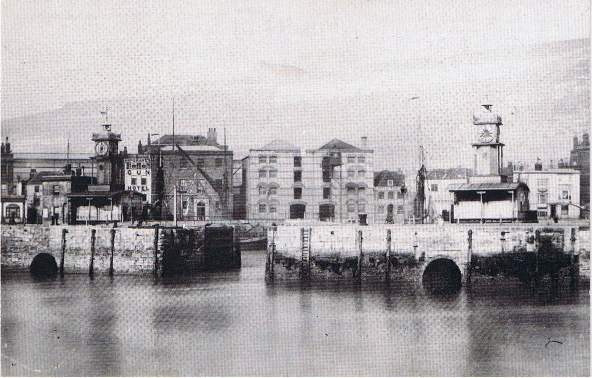
Look for old postcards, they are easy to find!!!!!!!!! Picadilly Circus 1940 (staue removed):  Dover Pier (Admiralty pier). I sent this link to Jutocsa over a year ago: 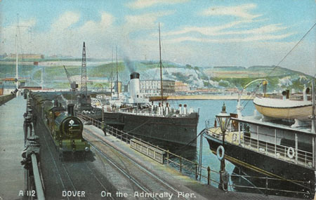 http://images.google.se/imgres?imgur...OJnI-Qay-ZCADA here is another, unknown date: 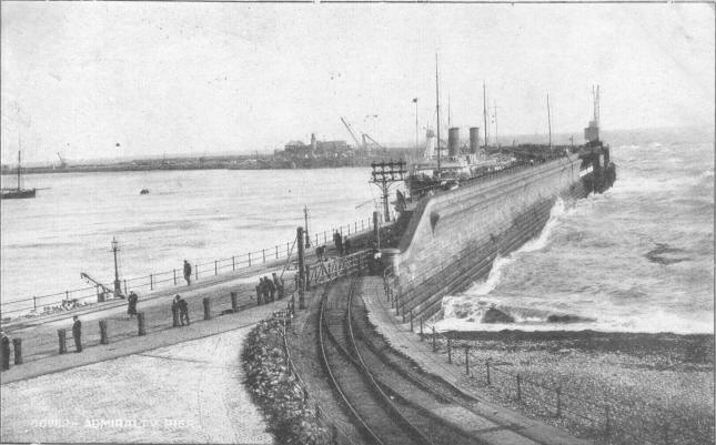 http://images.google.se/imgres?imgur...OJnI-Qay-ZCADA http://www.reminiscene.co.uk/postcards/0471.jpg Dover - Prince of Wales pier , unknown date: 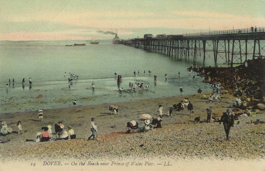 Prince of Wales pier: 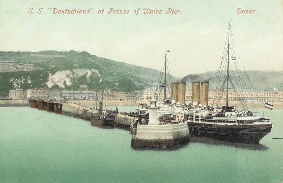 Promenad Pier Dover, early 1940's: [Edit - Removed on request. It was demolished before 1940]. Old photos Dover: http://images.google.se/imgres?imgur...JdPC-Qbf6KT4Cw
__________________
All CoD screenshots here: http://s58.photobucket.com/albums/g260/restranger/ __________  Flying online as Setback. Last edited by major_setback; 03-10-2010 at 09:44 PM.
|
|
#17
03-09-2010, 09:37 PM
|
|||
|
|||
|
...
Piccadilly Circus  Piccadilly Circus October 1939  This structure covers the statue of King Charles I, Trafalgar Square and the National Gallery   House of Commons see from tah crossroads of Victotia Embankment and Bridge Street  http://maps.google.com/maps?layer=c&...GGOtzJOJ31wO8L London Trolley-bus  Trafalgar Square, March 1942  ... Last edited by Rodolphe42; 03-09-2010 at 10:08 PM.
|
|
#18
03-10-2010, 08:39 PM
|
||||
|
||||
|
Dover, unknown dates.
From this site http://www.old-postcards-of-dover.co.uk/ ...and... http://www.old-postcards-of-dover.co.uk/album/8 This may be useful:     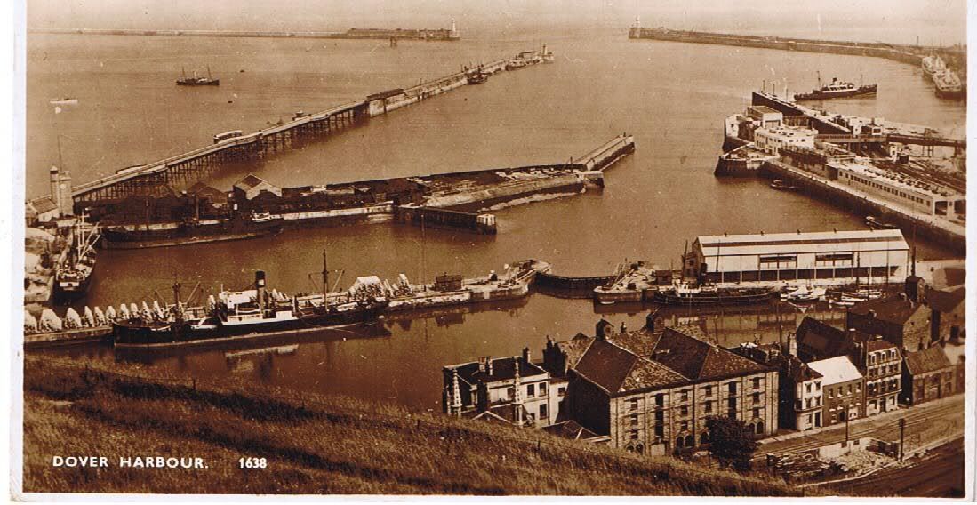 . [Edit :This pier was demolished/destroyed before 1939!] This shows the two 'towers' at the entrance of the pier. You can also see them in the next 2 photograph after this:                    DoverWesternDocks: 
__________________
All CoD screenshots here: http://s58.photobucket.com/albums/g260/restranger/ __________ Flying online as Setback. Last edited by major_setback; 03-10-2010 at 10:36 PM.
|
|
#20
03-10-2010, 09:35 PM
|
||||
|
||||
|
Continued...
              Newer:  
__________________
All CoD screenshots here: http://s58.photobucket.com/albums/g260/restranger/ __________ Flying online as Setback. Last edited by major_setback; 03-10-2010 at 10:23 PM.
|
 |
|
|


 Linear Mode

