
|
|
#41
 09-21-2012, 01:58 AM
|
|||
|
|||
|
Edit from first post found an Ooops in the calcs ... corrected made error even less. I deleted the original post and re post here.
Here is my contribution in trying to sort this perceived issue out. Happy for anyone to pull apart and destroy my method,calculations and or assumptions. SPEED TEST METHOD Picked 2 easily seen landmarks far enough apart to provide reasonable distance. 2 landmarks chosen Dungeness point lighthouse and Capr Griz Nez. Then measured actual real world distance in Google maps 42.59Km  Next in CLOD FMB established map Grid size via X coordinates between two adjoining vertical grid lines. This was 10,000 metres. In FMB set up BF109 at 10m over Dungenes point at 0700 hrs at 420Kmh. Set Destination Waypoint Griz Nez at 420Kmh. FMB Computed Time interval 6min. at 6min 420Kmh gives 42Km ... Close enough to real world distance. Conclusion CLOD map is 1:1, OK to use for time Distance Speed checks. 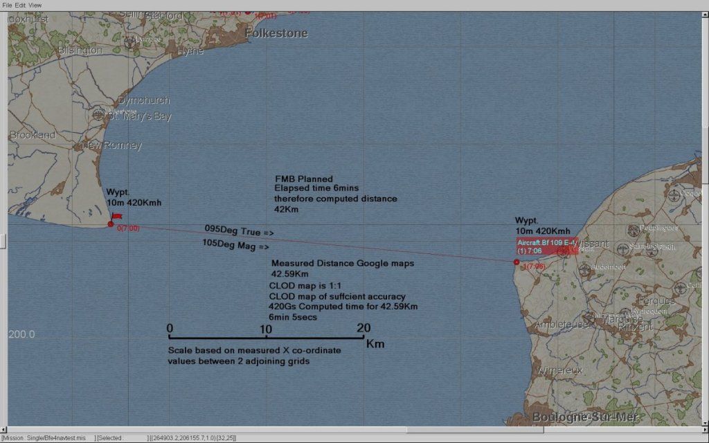 Set up Ships along the planned track to allow for easy navigation. Next Flew the course 4 times 2 East bound and 2 Westbound to ensure the cancellation of any hidden/latent winds on the map. (just as well) Each run commenced inland of the initial waypoint at Sea level Stabilised on speed 420Kmh IAS Wings level in Trim. Stop watch started over First waypoint and stopped over end waypoint IAS maintained +-5Kmh throughout using Wonder woman mode Large ASI. RESULTS: SE Bound Run1 Elapsed time 5:25 SE Bound Run 2 Elapsed time 5:23 NW Bound Run 1 Elapsed time 6:25 NW Bound Run 2 Elapsed time 6:18 (Average West bound runs take 57secs longer) Total Time 23min 51 secs Given the consistent significant diff between SE and NW runs I can only conclude that there is some hidden wind (or retroverted Coriolis) on the base map. Runs in both directions will negate Wind affect if results are averaged. Using Real World distances. 42.59Km X 4 = 170.36Km 170.36Km at 420Kmh would take 24min 20secs I achieved in CLOD test 23min 51 secs. So over say 23mins 51secs the diff was 29 seconds Over 1 hr the difference would be 73 seconds 73 seconds at 420Kmh equates to 8.51Km Experimental speed error 8.51Kmh i.e. about 2.0% Considering all the various potential errors in the methodology: Google map distance measurement CLOD FMB map accuracy Exact Stopwatch activation location Slight IAS piloting errors Assuming IAS=TAS at Sea level (which we know is close but not exact) a 2.0% or in real numbers 8.5 kmh variance is insignificant . Conclusion Displayed BF109E4 IAS is accurate. NOTES Be careful using timed runs over geographic features as some hidden wind is IMO resident on the base map. Flying the track both ways and averaging the results should cancel out the wind effect. If you want to test the RAF types then the target IAS based on Statue mile would be 261MPH. Test Mission file attached Last edited by IvanK; 09-21-2012 at 08:42 AM. 
|
|
#42
09-21-2012, 03:42 PM
|
|||
|
|||
|
Nice idea, IvanK. One remark for better accuracy - you need to calculate the average speeds for each direction separately and then take the average, not take total time and calculate then.
Total time for 170.36 km in 23:51 equals 429 km/h. Two times leg 1 for 85.18 km in 10:48 equals 473 km/h. Two times leg 2 for 85.18 km in 12:43 equals 402 km/h. Individual Leg 1 and 2 averaged - 438 km/h, 9 km/h more than from entire distance average. Looks like a 10 m/s wind. Also food for thought, if wind direction is in some way sideways, it will also effect figures as the plane cannot fly directly at the target, but needs to be pointed upwind. For high speed fighters, the effects will be small at best and can be neglected, but for slow planes it might become a bit more important. Last edited by JtD; 09-21-2012 at 06:50 PM.
|
|
#44
09-21-2012, 06:59 PM
|
||||
|
||||
|
Quote:
But as you said, there's much room for errors (especially since you flew the plane yourself and didnt let the autopilot fly). Why make it so sophisticated? Take a Hurry Rotol and set it up in FMB. Fly 3 minutes and measure thr distance (with marks on and using the ruler) and compare it to the computed figure. I got roughly 3km difference in only 3minutes! Which is a lot! So I assume the gauge doesnt work correctly especially now that you've prooven that the map is ok and 1:1 to the real world. Pleas do it, I don't want to be the only one pretending the speed gauge is incorrect. Im also happy to be refulated but it's strange that you came to the conclusion that everything is ok... Looking forward to your results! Last edited by NaBkin; 09-21-2012 at 07:01 PM.
|
|
#46
09-21-2012, 08:57 PM
|
||||
|
||||
|
Quote:
I think KG_26 Alpha pointed out that the developers are aware of the gauge problem. So I think any further testing is not needed, the ball is in the devs court now. If I could read Russian I would look at the bug tracker, just to see its status.
__________________
 GigaByteBoard...64bit...FX 4300 3.8, G. Skill sniper 1866 32GB, EVGA GTX 660 ti 3gb, Raptor 64mb cache, Planar 120Hz 2ms, CH controls, Tir5
|
|
#48
09-22-2012, 03:42 AM
|
|||
|
|||
|
Here are the test results using Spit IIA. Again feel free to pick this apart both Maths wise,method wise and the conclusion.
Firstly I checked the file properties and ensured that all "Flow" and "wind" values are deleted. However they always return when you next enter the mission. METHOD Same as before however 261MPH (420Kmh) was a bit too fast to achieve with the current CEM/FM so elected to use 240MPH on the ASI this also gave a simple reference to fly using Wonder woman display mode. Again East bound times were shorter than West bound times. Implying that some latent wind is still present on the map. 2 runs each way were flown. IAS maintained to within +-1mph each run. I then averaged as per JTD's suggestion by average Eastbound values then average westbound values then a combined average. RESULTS: East Bound Run 1: 6min 14secs East Bound Run 2 : 6min 12secs Avg of both East bound run times : 6min 13secs West Bound Run 1: 6min 36secs West Bound Run 2: 6min 33secs Avg of both West Bound time: 6min 34secs Overall Avg time for 42.59Km: 6min 23 Secs. Converting MPH to KMH 240MPH = 386.3KMH Time to fly 42.59Km at 386.3KMH IRL 6min 36secs I flew 42.59Km in an average time of 6min 23secs 42.59Km in 6min 23secs works out at speed of 400.53Kmh So speed error is 13.23Kmh (8.2MPH)or about 3.6% CONCLUSION: Again considering the potential errors in the test method same as BF109 case I think its close enough. Spitfire ASI is accurate. Its worth noting that even IRL you will get some Instrument errors. All Flight test reports will have some correction table. Notes: No matter if you delete all "Flow" or "Wind" some latent wind is always present on the map. Maybe significant for the level bombers and explain some of the strange IAS/TAS sight setting issues and workarounds that are being employed to get bombs on target. Last edited by IvanK; 09-22-2012 at 04:48 AM.
|
|
#49
09-22-2012, 06:55 AM
|
||||
|
||||
|
Hi Ivank
is it possible to determine the direction of the inherent wind in CoD or are you finding it varies depending on location? If only 1C would tell us what they've given us! Incidentally, rather than delete Flows I set all 'Flow' values to 0 in FMB and saved it. When I re-opened it and looked at them again everything was still 0 except gust angle and effect. I did not change anything and closed the mission at which point it asked if I wanted to save changes and I said no. So, I wonder if all the zero values were all still held in the mission and the gusts/effects are defaults in the Flow panel which, when you go into Flows, edits them into the mission but they don't really get applied unless you do save them. Fortunately I don't think this will affect IAS/TAS tests, only navigation/bombing.
__________________
klem 56 Squadron RAF "Firebirds" http://firebirds.2ndtaf.org.uk/  ASUS Sabertooth X58 /i7 950 @ 4GHz / 6Gb DDR3 1600 CAS8 / EVGA GTX570 GPU 1.28Gb superclocked / Crucial 128Gb SSD SATA III 6Gb/s, 355Mb-215Mb Read-Write / 850W PSU Windows 7 64 bit Home Premium / Samsung 22" 226BW @ 1680 x 1050 / TrackIR4 with TrackIR5 software / Saitek X52 Pro & Rudders
|
|
#50
09-22-2012, 08:28 AM
|
|||
|
|||
|
Yes you should be able to calculate the wind Direction from the Trk and groundspeed. Though shudder at the possibility that wind input will use the Russian penchant to use were the wind is blowing to rather than the aviation standard of where it is coming from
In general terms we know its a "Northerly" I will get my "prayer wheel' out and start doing some vectors. Good idea on setting it to zero rather than just deleting it. Last edited by IvanK; 09-22-2012 at 08:30 AM.
|
 |
|
|


 Linear Mode

